World Trade Center/World Financial Center Pedestrian Passageways Network
| arcade (architecture), pedestrian area, underground facility
USA /
New Jersey /
Hoboken /
World
/ USA
/ New Jersey
/ Hoboken
arcade (architecture), pedestrian area, invisible, underground facility, do not draw title
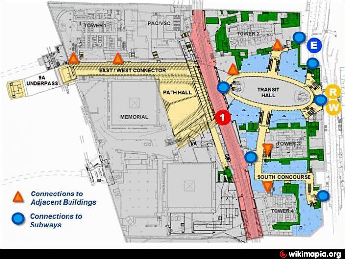
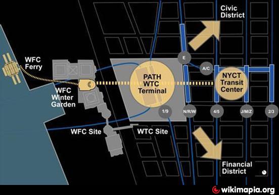
This is the network of underground pedestrian passageways and underpasses arranged to provide maximum connectivity for transit passengers coming to and leaving from the combined new World Trade Center and already existing World Finance Center Campuses respectively.
It is centered on the new World Trade Center Transportation Hall building but it also provides subterranean pedestrian access across the greater part of the lower Downtown part of Manhattan Island.
It also provides connections to the World Trade Center PATH station and the New York City Transit Authority subway station on the IRT Broadway – Seventh Avenue Line and is served by the '1' train service, and finally also all the way to the WFC ferry terminal on the Hudson River itself. There is also subterranean access to the principal following buildings, all of the World Financial Center; the New York Mercantile Exchange (NYMEX), Three World Trade Center, Four World Trade Center, the Winter Gardens Building and One World Trade Center.
On the east side access is access to IND Eighth Avenue Line and IRT Broadway – Seventh Avenue Line of the New York City Subway at the Chambers Street – World Trade Center / Park Place station complex which is served by the 2,3,A,C & E train services and also to the BMT Broadway Line Station at Cortlandt Street and thus to the N & R train services.
Finally, a new passage way under Dey Street, east of Cortlandt Street Station, provides access to the Fulton Street Transit Center Building @ the SE corner of Fulton Street and Broadway which in turn provide further access to the 2,3,4,5,A,C,J & Z train services among others. When complete it will be the most integrated public transport interchange in the City.
Construction work has begun on parts of the network with the development of the underground elements of the new WTC PATH Station (September 2011) and the foundations for the new WTC Transit Hall (July 2008).
Nearby cities:
Coordinates: 40°42'44"N 74°0'47"W
- Mackinac Island 1035 km
- Chain of Rocks Bridge 1399 km
- 16th Street Mall 2622 km
- Promenade Temecula 3872 km
- Martin Luther King Jr. Promenade 3912 km
- Pedestrian zone 4126 km
- Princes Street Gardens 5250 km
- New Brighton 5325 km
- City Centre Precincts 5376 km
- Estoril Cascais promenade 5407 km
- World Trade Center 0.1 km
- Battery Park City 0.3 km
- Northern Quarter 0.4 km
- Financial District 0.7 km
- TriBeCa 0.9 km
- Lower (Downtown) Manhattan 1.8 km
- Hudson County, New Jersey 5.5 km
- Manhattan 8.4 km
- Brooklyn 10 km
- Queens 14 km