Bahubal Upazila HQ
Bangladesh /
Habiganj /
World
/ Bangladesh
/ Habiganj
/ Habiganj
World / Bangladesh / Sylhet / Sylhet / Hobiganj
township, subdistrict, fourth-level administrative division, local government
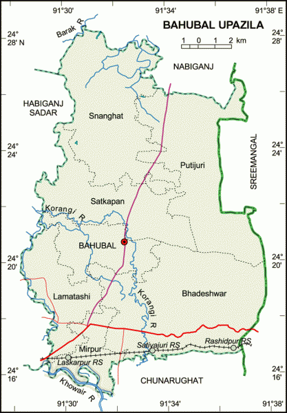
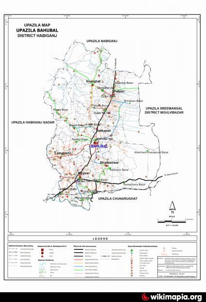
Bahubal Upazila (Habiganj district) with an area of 250.66 sq km, is bounded by Nabiganj upazila on the north, Chunarughat upazila on the south, Sreemangal upazila on the east and Habiganj sadar upazila on the west. Main rivers are Korangi, Shwasanali, Yojnal, Kalishiri; haor 10; beel 68.
Bahubal is located at 24.3556°N 91.5417°E. It has 25208 units of house hold. Bahubal (Town) consists of 2 mouzas with an area of 2.12 sq. km. The town has a population of 2560; male 53.09%, female 46.91%; dessity of population is 1208 per sq km. Literacy rate among the town people is 48.3%. The town has one dukbanglow.
Bahubal thana, now an upazila, was established in 1921. It consists of 7 union parishads, 145 mouzas, 325 villages.
Historical events Afghan king Khwaja Osman left Bukai Nagar Fort and established shelter at Putijuri on the foot of the Giripal. He established a fort here for defence.
As of 1991 Bangladesh census, Population 137402; male 50.58%, female 49.42%; Muslim 82.66%, Hindu 17%, Christian 0.25%, others 0.09%; ethnic nationals: khasia, Tipra and manipuri.
Religious institutions Mosque 197, temple 14, tomb 3, most noted of which are Bahubal Jami Mosque, Putijuri Jami Mosque.
Average literacy 23%; male 28.8%, female 17.1%. Educational institutions: college 1, high school 7, government primary school 75, non-government primary school 22, madrasa 15. Noted educational institutions: Dina Nath Institute (1937).
Main occupations Agriculture 46.65%, agricultural labourer 19.85%, wage labourer 6.61%, commerce 6.97%, service 3.62%, others 13.01%.
Land use Total cultivable land 2367.38 hectares; fallow land 46.04 hectares; single crop 48.10%, double crop 39.51% and treble crop 12.39%; tea garden 3.
Land control Among the peasants 11.96% are landless, 39.62% marginal, 26.41% small, 17.6% intermediate and 4.41% rich.
Fisheries, dairies, poultries Fishery 8, poultry 58, dairy 26,.
Communication facilities Roads: pucca 34 km, mud road 79 km; railways 10 km.
Health centres Upazila health complex 1, union health and family planning centre 7, satellite clinic 2, veterinary hospital 1.
NGO activities Operationally important NGOs are brac, caritas, asa, proshika.
Nearby cities:
Coordinates: 24°20'30"N 91°32'17"E
- Kapashia Upazila 107 km
- Rupganj Upazila 110 km
- Gafargaon Upazila 112 km
- Matlab Upazila (North) Area 136 km
- Keraniganj Upazila 146 km
- Dhobaura Upazila 154 km
- Lohajang Upazila 160 km
- Patiya Upazila (পটিয়া) 223 km
- Chandanaish Upazila 233 km
- Banshkhali Upazila (বাঁশখালী উপজেলা) 242 km
- Habigonj District 12 km
- Habiganj Dist Town 13 km
- Haail Haaor 14 km
- Fisheries 15 km
- Deundi Tea Estate 19 km
- Gias Nagar, U.C 12, Moulvi bazar 21 km
- Maulvibazar District Town 29 km
- Sylhet Division 34 km
- Maulvibazar District 43 km
- Tripura 71 km