Fort Finney
USA /
Indiana /
Lawrenceburg /
World
/ USA
/ Indiana
/ Lawrenceburg
World / United States / Ohio
historical layer / disappeared object
Add category
(1785 - 1788)
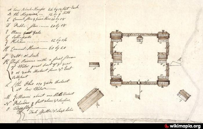
A Federal fort located at the mouth of the Great Miami River, built to enforce
the Treaty of Fort McIntosh that was signed by several Indian tribes at Fort McIntosh,
PA in January 1785. The Treaty of Fort Finney was signed in January 1786. The fort
was abandoned for Fort Finney, Indiana. Site marked at the entrance to the Cincinnati
Gas and Electric Miami Fort Power Plant on Brower Road.
Nearby cities:
Coordinates: 39°6'40"N 84°48'37"W
- Cincinnati Subway (Abandoned) 24 km
- Air Force Plant No. 36 35 km
- Jefferson Proving Ground 58 km
- Former PRR Bradford terminal & yard 118 km
- GM Guide Lamp Division Anderson, IN Plant (site) 134 km
- Flinn Township (extinct) 135 km
- Indiana National Guard - Stout Field Armory 141 km
- 2009 Fayetteville tornado 158 km
- Point of Entry of the Wabash River into Indiana 162 km
- Miami & Erie Canal 235 km
- Shawnee Lookout Park 1.7 km
- Oxbow Wetlands Sanctuary 2.5 km
- Dearborn County, Indiana 14 km
- Boone County, Kentucky 17 km
- Miami Whitewater Forest 18 km
- Hamilton County, Ohio 24 km
- Morgan Township, Butler County, Ohio 27 km
- Ripley County, Indiana 37 km
- Franklin County, Indiana 38 km
- Butler County, Ohio 42 km