HAARP - S Band Aircraft Alert Radar
USA /
Alaska /
Gakona /
World
/ USA
/ Alaska
/ Gakona
World / United States / Alaska
radar station, interesting place, early warning radar
The HAARP Gakona Facility employs a Faruno S-Band radar to detect all aircraft that may be in the vicinity of the facility. The radar is used to alert the control operator during research operations so that any high power transmitters on-site can be shut down. This Aircraft Alert Radar can detect planes at altitudes as low as 500 feet at 8 miles. As a supplement and to improve detection performance, the radar installation uses a modified TCAS system to interrogate planes within range that carry transponders. The resulting automatic replies allow the plane's altitude to be shown on the display console adjacent to the normal radar return.
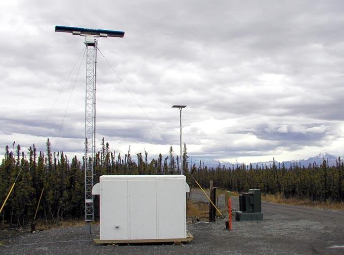
In the photo to the left, the taller mast supports the main rotating antenna for the S-Band radar. The smaller mast supports a four monopole array used by the modified TCAS equipment to interrogate transponders in the vicinity and to determine the bearing for any responses. A larger image of the radar is available (34 K jpg).
The shelter shown in the image is used to house the S-Band transmitter, SSR PC-RP™ radar processor and TCAS system. Processed information is sent from the trailer to the Operations Center and the control operator position by a fiber optic link. A large UPS is also located in the trailer to protect the equipment from power interruptions.
Some of the specifications for this radar include:
Radar Transceiver: Furuno Model RTR018/60S
60 kW Peak Power S-Band Radar Transceiver
State-Of-The-Art Maritime Radar
MTD Target Detection Capability
SSR Engineering Processor: Model PCRP-202
Radar Control and Post-Detection Signal Processing
Pentium IV PC Platform with Solid-State Disk Storage
Range: Maximum: 96 nMiles, Minimum: .1 nMile
Detection threshold 1 m2 at range 7 miles, altitude 500 feet.
The display console for the radar system is driven by a standard workstation with software that allows a map overlay and custom setting of range rings. The display console is installed at the main control operator's position. The radar system was installed by BAE Systems Advanced Technologies and the Naval Air Warfare Center (PAX River) with assistance from the Oceantronics Corporation during July and August 2003.
Nearby cities:
Coordinates: 62°23'46"N 145°10'8"W
- Clear Air Force Station 296 km
- Former Tin City Air Force Station 1163 km
- Christmas Valley Air Force Station 2665 km
- Tulelake Air Force Station 2788 km
- CFS Beausejour 3218 km
- Helendale RCS Facility 3629 km
- Gray Butte Radar Cross-Section Facility 3642 km
- RAMS 4228 km
- Tethered Aerostat Radar System 4597 km
- Tethered Aerostat Radar System 5226 km
- Mount Drum (12,010ft) 41 km
- Tazlina Lake 86 km
- Klutina Lake 88 km
- Nabesna Glacier 113 km
- Kennicott Glacier 143 km
- Tetlin Lake 146 km
- Gerstle River Arctic Test Site 155 km
- Donnelly Training Area, AK 174 km
- Fort Greely, AK 176 km
- Carden Hills 206 km
Comments