Peritheorion
Greece /
Rodypi /
Amaxades /
World
/ Greece
/ Rodypi
/ Amaxades
, 3 km from center (Αμαξάδες)
World / Greece / Anatoliki Makedonia kai Thraki
temple, castle, archeological site, fortification, Roman Empire, interesting place, ancient ruins
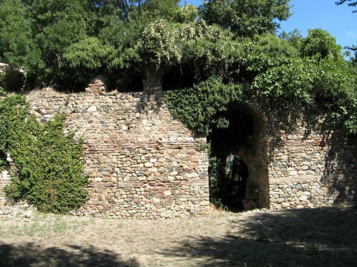


The overgrown ruined site of an ancient and medieval Roman settlement southeast of modern Amaxades, which was called Anastasioupolis after Emperor Anastasios I (491-518) and later Peritheorion. It is recorded as taken and destroyed by the Bulgarian emperor Kalojan (1197-1207) in 1205, but was later restored, in the reign of Emperor Andronikos III Palaiologos (1328-1341). A battle fought near Peritheorion in 1345 witnessed the victory of Umur Bey of Aydin and Emperor Ioannes VI Kantakouzenos over Momčil. If the "Palateoria" of an Italian document is Peritheorion, the town and its salt pans were restored to Emperor Manuel II Palaiologos (1391-1425) by the Ottoman emir Süleyman Çelebi by treaty in 1403. The Turkish name of the town was Buru or Buri.
Nearby cities:
Coordinates: 41°6'7"N 25°5'28"E
- Aqueduct & Wall of Ancient Anastasioupolis - Peritheorion 2.5 km
- Old Castle Walls 21 km
- Castle of St. John - Agiannis 69 km
- Ancient city of Philippi 69 km
- "Gradishte" Fortification 75 km
- Zarenica Fortress 91 km
- "Hisarlaka" Fortress 99 km
- Thracian and Ancient Fortress "Momitsa /Momina Krepost" 111 km
- Sanctuary with big stone heads 113 km
- Medieval fortress "Koileto" 125 km
- Bistonis Lagoon 7.8 km
- Abdera Μunicipality 9 km
- Iasmos Municipality 12 km
- Lafri 12 km
- National Park of East Macedonia and Thrace 14 km
- Peripheral unit of Xanthi 21 km
- Κomotini Municipality 22 km
- Xanthi Municipality 28 km
- Peripheral unit of Rodopi 31 km
- Thracian Sea 72 km