Sondai Fort
India /
Maharashtra /
Karjat /
World
/ India
/ Maharashtra
/ Karjat
World / India / Maharashtra / Raigarh
forts, hillfort, rampart (fortification)
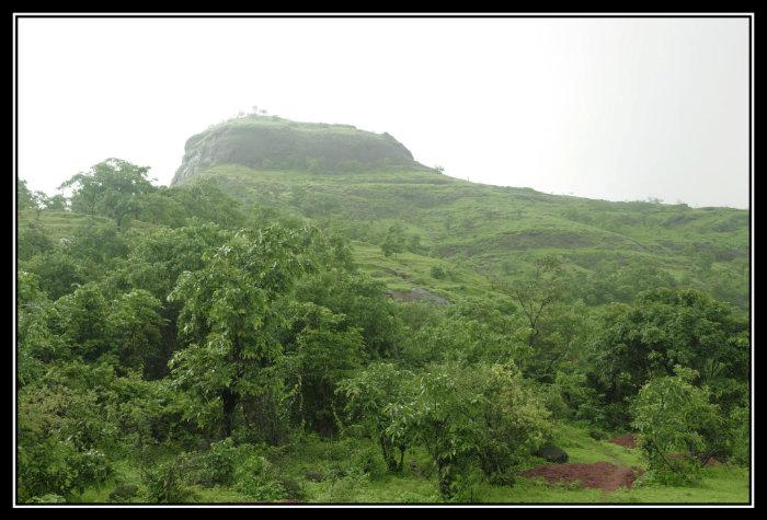
Sondai is not a popular fort. It stands 6kms west of Karjat overlooking the Karjat-Chowk highway and offers a beautiful view of Morbe Dam, Prabalgad, Irshalgad, Rajmachi, Songiri forts and Matheran mountain range. This was used as watch tower. The base village of Sondewadi stands on a considerable height and can be reached by autos from Karjat. The route is easy and it takes approx 1.5 hrs to reach the top. In monsoon, a couple of rocks on the way becomes slippery. There are 2 water cisterns on machi (at the base of the pinnacle) and steps are carved out of rocks to go on the topmost point where an idol of Sondai Devi stands. Two more water cisterns are on the way and has potable water. Two missing steps in the rock makes one to climb a small patch of 15 feet but proper hand holds and foot steps are available and that makes it easy even in monsoon. Wavarle is another village from where a bit difficult approach to the fort passes through the dense forest. Overall it's an ideal one day hike in monsoon for new comers in the trekking field.
Link of Photographs: picasaweb.google.com/106951269103803464227/SondaiFort
Link of Photographs: picasaweb.google.com/106951269103803464227/SondaiFort
Nearby cities:
Coordinates: 18°56'44"N 73°17'45"E
- Vikatgad 11 km
- Rajmachi 16 km
- Raigad Fort 80 km
- Rajgad Fort 87 km
- Purandar Fort 102 km
- Kamalgad 117 km
- Mallikarjun Parvat 135 km
- Bhupalgad 252 km
- Panhala 252 km
- Fortification Walls of Vijayapur 347 km
- Garbut plateau 3.4 km
- Morbe Lake and Dam 4.1 km
- Bhilavle Dam 5.1 km
- Matheran Hill Station 5.4 km
- Earthen filling for Morbe Dam 5.5 km
- Nitin Desai Studio 6.2 km
- Nadhal Dam (Lower) 8.1 km
- Khalapur Taluka 10 km
- Karjat Taluka 11 km
- Panvel Taluka 20 km