National Geospatial-Intelligence Agency (Former site) (Washington, D.C.)
USA /
District of Columbia /
Washington /
Washington, D.C. /
M Street Southeast, 213
World
/ USA
/ District of Columbia
/ Washington
World / United States / District of Columbia
national government / government, military, historical layer / disappeared object
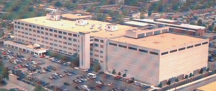
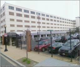
The National Geospatial-Intelligence Agency (NGA) provides timely, relevant and accurate geospatial intelligence in support of national security objectives. The term “geospatial intelligence” (GEOINT) means the exploitation and analysis of imagery and geospatial information to describe, assess and visually depict physical features and geographically referenced activities on the Earth. Geospatial intelligence consists of imagery, imagery intelligence and geospatial (e.g., mapping, charting and geodesy) information. jfkcountercoup.blogspot.com/2010/02/washington-navy-yar...
www1.nga.mil/Pages/Default.aspx
As of 2010, NGIA has moved to a new complex at Fort Belvoir.
www1.nga.mil/Pages/Default.aspx
As of 2010, NGIA has moved to a new complex at Fort Belvoir.
Wikipedia article: http://en.wikipedia.org/wiki/National_Geospatial-Intelligence_Agency
Nearby cities:
Coordinates: 38°52'31"N 77°0'17"W
- National Institutes of Health (NIH) 17 km
- USDA-ARS Beltsville Area Research Center West 19 km
- Fort Belvoir - North Post 20 km
- Henry A. Wallace Beltsville Agricultural Research Center (BARC) 21 km
- NIST - National Institute of Standards and Technology 35 km
- Marine Corps Base Quantico 55 km
- AT&T Project Office "Peters Mountain" Virginia 139 km
- Buena Vista Conference and Reception Center 145 km
- Ommelanden Range 146 km
- Picatinny Arsenal 313 km
- Nationals Park 0.4 km
- Washington Navy Yard 0.9 km
- Capitol Riverfront 0.9 km
- Interstate 395 Exits 5-6-7-8 and Interstate 695 Exit 1C 1.1 km
- Southwest Waterfront 1.2 km
- Capitol Hill 1.4 km
- Capitol Grounds 1.8 km
- Southwest Federal Center 1.8 km
- Anacostia Park 1.9 km
- The National Mall 2.8 km