Pyote AFB
USA /
Texas /
Pyote /
World
/ USA
/ Texas
/ Pyote
World / United States / Texas
historical layer / disappeared object
Add category


Pyote AAF Base
Pyote Air Force Base was a World War II United States Army Air Forces training airbase. It was on 2,745 acres (1,111 ha) a mile from the town of Pyote, Texas on Interstate 20, twenty miles west of Monahans and just south of U.S. Highway 80, 230 miles (370 km) east of El Paso.
It was nicknamed "Rattlesnake Bomber Base" for the numerous rattlesnake dens that were uncovered during its construction.
At the height of its use in 1944, the base had over 6,000 officers and enlisted men either permanently assigned or temporarily attached. In addition, there were hundreds of civilians that came from all over the United States to work on the base.
After World War II, thousands of reserve aircraft were stored there, one of which was the B-29 "Enola Gay".
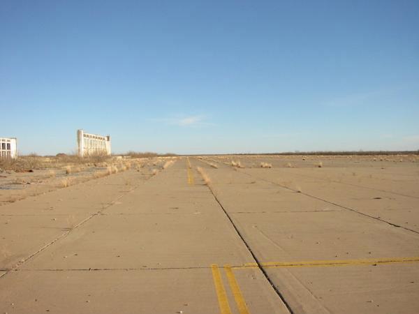
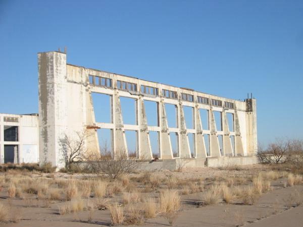
Today, most of the base is gone. Other than the concrete runways, taxiways and ramp, virtually nothing remains that would tell the casual observer that this was once a major training center responsible for turning out highly trained flying crews. the West Texas State School is now situated on the site. Located on I-20 at exit 66.
www.airfields-freeman.com/TX/Airfields_TX_W.htm#pyote
Pyote Air Force Base was a World War II United States Army Air Forces training airbase. It was on 2,745 acres (1,111 ha) a mile from the town of Pyote, Texas on Interstate 20, twenty miles west of Monahans and just south of U.S. Highway 80, 230 miles (370 km) east of El Paso.
It was nicknamed "Rattlesnake Bomber Base" for the numerous rattlesnake dens that were uncovered during its construction.
At the height of its use in 1944, the base had over 6,000 officers and enlisted men either permanently assigned or temporarily attached. In addition, there were hundreds of civilians that came from all over the United States to work on the base.
After World War II, thousands of reserve aircraft were stored there, one of which was the B-29 "Enola Gay".
Today, most of the base is gone. Other than the concrete runways, taxiways and ramp, virtually nothing remains that would tell the casual observer that this was once a major training center responsible for turning out highly trained flying crews. the West Texas State School is now situated on the site. Located on I-20 at exit 66.
www.airfields-freeman.com/TX/Airfields_TX_W.htm#pyote
Nearby cities:
Coordinates: 31°30'39"N 103°8'17"W
- Union Pacific Railroad initiated "Hughes Ranch Fire" region 164 km
- Salt Flat Intermediate Field 187 km
- Porvenir, Texas 203 km
- Original Lajitas Airport 17XS, Lajitas, TX 257 km
- Horizon Estates -- Failed Development 294 km
- Eastlake Marketplace 298 km
- Farah Clothing Company factory (site) 308 km
- El Paso Municipal Airport (site) 314 km
- Old Railroad Track Bed 610 km
- Caesars Palace Hotel Los Cabos (cancelled) 1141 km
- Pyote AAF Base (Closed) 0.2 km
- Pecos high speed test track 29 km
- Monahans Sandhills State Park 33 km
- Pecos Municipal Airport (PEQ/KPEQ) 38 km
- Oberon Solar and Storage 48 km
- Notrees Wind Farm 60 km
- Bridgestone/Firestone Proving Grounds 65 km
- Fort Stockton-Pecos County Airport (FST/KFST) 70 km
- Red Bluff Lake 91 km
- Buffalo Trails Scout Ranch 111 km
Comments