Denning Point (London)
United Kingdom /
England /
London /
A1202 Commercial Street
World
/ United Kingdom
/ England
/ London
World / United Kingdom / England
high-rise, residential neighbourhood
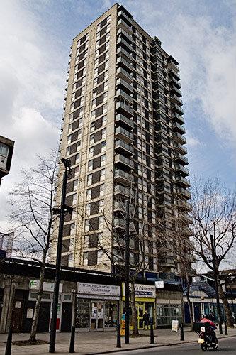
Dubbed the "heroin high rise", the 23 floors tower is said to be "ruled by heroin users and prostitutes".
Nearby cities:
Coordinates: 51°30'59"N -0°4'23"E
- The Willis Building 0.7 km
- Lloyd's Building 0.7 km
- 60 Threadneedle Street 1 km
- Drapers Gardens 1 km
- Cannon Place 1.3 km
- Tradescant House 3.2 km
- Rowe House 3.6 km
- Central Saint Giles 3.8 km
- Foxfield 5.2 km
- Morgan House 5.7 km
- Goodman's Fields 0.4 km
- Berner Estate (north) 0.8 km
- Whitechapel 0.8 km
- The Tower of London 0.9 km
- St Georges Estate 1 km
- Regent’s canal 1 km
- St. George in the East 1 km
- Walled Perimeter of Roman Londinium 1.2 km
- Tower Hamlets Council 2.7 km
- Central London 3.4 km