Debidwar (Upazila)
Bangladesh /
Komilla /
World
/ Bangladesh
/ Komilla
/ Komilla
World / Bangladesh / Chittagong / Comilla / Comilla
township
Add category

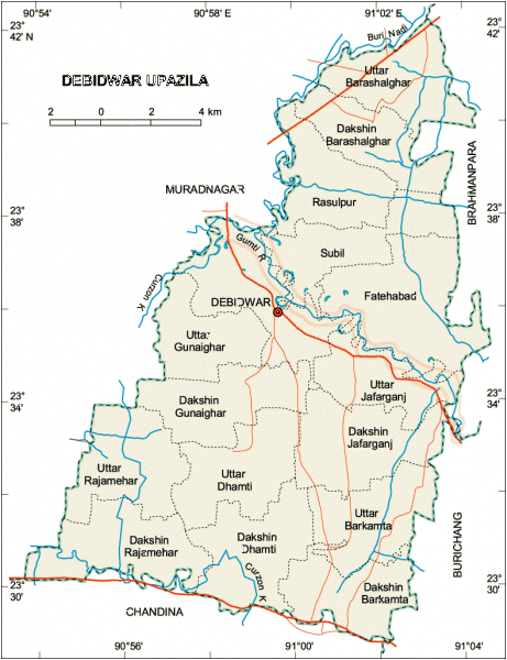
Debidwar Upazila (Comilla district) in Chittagong Division with an area of 238.36 sq km, is bounded by Muradnagar upazilas on the north, Chandina upazila on the south, Burichang and Brahmanpara upazilas on the east, Muradnagar upazila on the west. Main rivers are Gumti and Buri.
The location of the Debidwar town is 23.6011921N 90.986754E. Debidwar (Town) consists of two mouzas. Its area is 4.32 sq km. It has 55619 units of house hold and total area 238.36 km². The town has a population of 9782; male 52.32% and female 47.68%; population density per sq km 2264. Literacy rate among the town people is 56.9%.
As of 1991 Bangladesh census, Debidwar has a population of 336877. Males constitute are 50.33% of the population, and females 49.67%. This Upazila's eighteen up population is 158356. Debidwar has an average literacy rate of 35.1% (7+ years), and the national average of 32.4% literate.
Debidwar thana was established in 1915 and was turned into an upazila in 1980. The upazila consists of 16 union parishads, 141 mouzas, 201 villages.
As of the 1991 Bangladesh census: Population 336877; male 50.33%, female 49.67%; Muslim 93.24%, Hindu 6.5% and others 0.26%.
Religious institutions Mosque 451, temple 27, tomb 9.
Literacy and educational institutions: Average literacy 35.1%; male 43.65%, female 26.5%. Educational institutions: college 9, high school 43, madrasa 29, government primary school 120, non-government primary school 37, low cost school 18 and satellite school 17. Noted educational institution: Debidwar Reazuddin High School (1918).
Cultural organisations: Club 57, theatre group 1 and press club 1.
Main occupations: Agriculture 53.68%, commerce 10.12%, service 10.09%, agricultural labourer 13.75%, wage labourer 1.6%, transport 2.8% and others 7.96%.
Land use: Total cultivable land 16179.68 hectares; fallow land 1075 hectares; single crop 3.75%, double crop 41.27% and treble crop 54.98%.
Land control: Among the peasants 18.38% are landless, 25.31% marginal, 31.15% small, 23.68% intermediate and 1.48% rich; land per head 0.15 hectare.
Fisheries, dairies, poultries Fishery 7, dairy 5, poultry 30.
Communication facilities- Roads: pucca 38.31 km, semi pucca 20 km, mud road 450 km; waterways 14 nautical mile.
Manufactories Jute mill 4, cold storage 3, ice factory 5 and brick field 7.
NGO activities: Operationally important NGOs are brac, asa, grameen bank, Pages, nijera kari, Vitamin A Project, Agro Care, Speed and SDA.
Health centres: Upazila health complex 1, family planning centre 12 and CMH unit 1.
Nearby cities:
Coordinates: 23°36'13"N 90°59'22"E
- Kachua Upazila HQ 29 km
- Shahbazpur Town 55 km
- Kamalnagar Upazila HQ 94 km
- Ramgati Upazila HQ 103 km
- Manikchari Upazila HQ 117 km
- Sandwip Upazila HQ 130 km
- Betagi Upazila HQ 157 km
- Kathalia Upazila HQ 158 km
- Mirzaganj Upazila HQ 158 km
- Kaptai Upazila HQ 172 km
- Gunaighar 2.4 km
- Companigong Bazar 4.4 km
- Nabipur Village 6.1 km
- Kangshonagar 6.7 km
- BARASHALGHAR 10 km
- firujabad fishery 12 km
- BRISTIPUR BAZAAR,MURADNAGAR,COMILLA. 13 km
- est gram 13 km
- Dighi 14 km
- Korbanpur 15 km