Bagalkot
India /
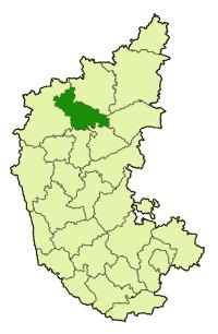
Karnataka /
Bagalkot /
World
/ India
/ Karnataka
/ Bagalkot
World / India / Karnataka / Bagalkot
town, taluka headquarter, district headquarter
Tehsil Bagalkot, District Bagalkot (Bagalkot), Karnataka, Bharat
Bagalkot (ಬಾಗಲಕೋಟೆ in Kannada) is a city in the Indian state of Karnataka. Is a pretty old town in north Karnataka located on Ghataprabha river bank very near to Krishna river. Chalukya dynesty (6th to 8th centuty) ruled Most of the southern part in India south of Narmada river. Capital of Chalukya Badami is situated about 25 kms. south of Bagalkot. Historic Aihole, Pattadakallu, Mahakoot, Menabasti, Banashakari temple and Holy historic Koodal samgam are very near from the city. Bagalkot is the district headquarters of the Bagalkot district of the state.Bagalkot district was carved from Bijapur(Vijapur) district.
New balglkot city is well planned and is south west of old city near Muchkandi dam. The old bagalkot was submerged due to the rising of the hight of Almatti dam(Upper Krishna Project) on River Krishna. Bagalkot latitude 16° 12' N , langitude 75° 45' E and altitude 533 mts. at railway staion and 531 mts. at Navanagar
Wikipedia article: http://en.wikipedia.org/wiki/Bagalkot
Nearby cities:
Coordinates: 16°10'4"N 75°39'40"E
- Gadag-Betgiri 79 km
- Dandeli 150 km
- Sirsi 192 km
- Ponda 199 km
- Margao 208 km
- Siddapura, Uttara Kannada 217 km
- Karwar 220 km
- Kumta 235 km
- Honnavar 246 km
- Bhatkal 269 km
- Sector No.9 0.6 km
- BRANDAVAN SECTOR 63A 0.8 km
- Sector No.25 0.9 km
- Sector 1 1 km
- Navanagar Bagalkot 1.1 km
- BVVS Medical College and Hospital 1.5 km
- Sector No. 41 1.7 km
- Sector No.43 2.1 km
- BEC Survey 2011 2.4 km
- Rajiv Gandhi Colony 2.6 km
Comments