Fomer Site of the Caven Point Army Depot (Jersey City, New Jersey)
USA /
New Jersey /
Jersey City /
Jersey City, New Jersey
World
/ USA
/ New Jersey
/ Jersey City
World / United States / New Jersey
historical layer / disappeared object
Add category
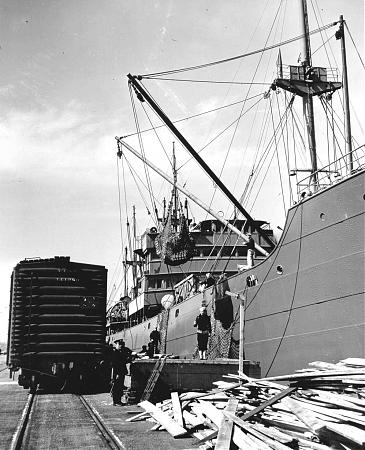
Operational from early 1900's until the early 1970's, the Caven Point Army Depot was a large US Army installation located on the tidal flats of Jersey City. During both World Wars, Caven Point's proximity to key rail networks and the ports of New York and New Jersey made it invaluable for the marshalling of troops, munitions and materials heading for front lines in Europe. A long finger pier extended over the shallow oyster beds into New York Harbor to allow for loading of deep-draft ships.
During WWII, the facility was one of the major points of embarkation of US soldiers heading overseas, and was also one of the major East Coast POW processing points for captured German and Italian troops during the war. Following the cessation of hostilities, Caven Point was a key receiving point for homeward bound American servicemen, and again used its proximity to US rail lines to send tens of thousands of troops on their way home.
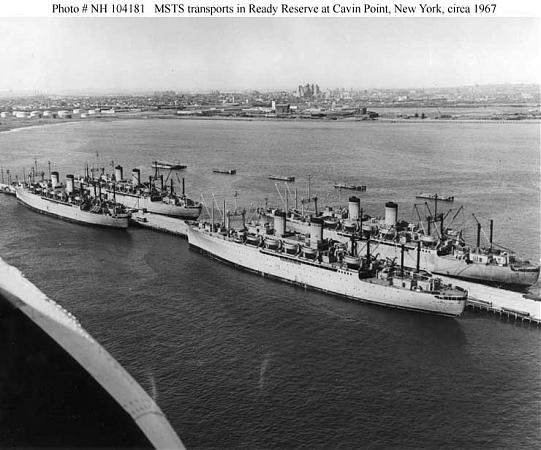
Following WWII, Caven Point became a dedicated troop facility, and its large finger pier became a storage point for US Army & Military Sea Transport Service troopships when they were not in active service. Caven Point was again called to action during both the Korean & Vietnam Wars, and also served as a transfer point for US personnel being returned stateside from foreign posts during the Cold War.
Budget cutbacks and the advancing age of the facility led to the Caven Point Army Depot to be drastically reduced in size during the late 1970's and the shoreside facilities were converted into a US Army Reserve Base which is still in operation today. The finger pier saw little use following the closure of the facility, though they became a popular local fishing spot until its demolition in the 1980's. The outermost landside section of the former terminal is now used by the US Army Corps of Engineers as their New York Harbor headquarters.
During WWII, the facility was one of the major points of embarkation of US soldiers heading overseas, and was also one of the major East Coast POW processing points for captured German and Italian troops during the war. Following the cessation of hostilities, Caven Point was a key receiving point for homeward bound American servicemen, and again used its proximity to US rail lines to send tens of thousands of troops on their way home.
Following WWII, Caven Point became a dedicated troop facility, and its large finger pier became a storage point for US Army & Military Sea Transport Service troopships when they were not in active service. Caven Point was again called to action during both the Korean & Vietnam Wars, and also served as a transfer point for US personnel being returned stateside from foreign posts during the Cold War.
Budget cutbacks and the advancing age of the facility led to the Caven Point Army Depot to be drastically reduced in size during the late 1970's and the shoreside facilities were converted into a US Army Reserve Base which is still in operation today. The finger pier saw little use following the closure of the facility, though they became a popular local fishing spot until its demolition in the 1980's. The outermost landside section of the former terminal is now used by the US Army Corps of Engineers as their New York Harbor headquarters.
Nearby cities:
Coordinates: 40°41'6"N 74°4'16"W
- Port Authority Auto Marine Terminal/NorthEast Auto Terminal (NEAT) (Site) 1.5 km
- PRR Greenville Yard 2.1 km
- Former CRR of NJ Railyards 2.9 km
- Brooklyn Street Circuit (former) 4.6 km
- Site of New Amsterdam 5.4 km
- Federal Shipbuilding & Drydock Co. Former Site 5.8 km
- Culver Shuttle (demolished) 8 km
- Former CNJ Newark Bay Drawbridge 8.5 km
- Bethlehem Steel/United Shipyard Former Site 9 km
- Staten Island Expressway/Richmond Parkway Interchange 9 km
- Port Liberte Housing Development 0.4 km
- Liberty National Golf Club 1 km
- Upper New York Bay 2 km
- Liberty State Park 2.5 km
- Greenville, Jersey City, NJ 2.5 km
- Our Lady of Mercy RC Parish 2.9 km
- Paulus Hook, Jersey City, New Jersey 3.9 km
- Hudson County, New Jersey 5.3 km
- CRRNJ Newark Branch (Partially Abandoned) 5.5 km
- Brooklyn 12 km
Comments