Jhenaigati Upazila HQ
Bangladesh /
Sherpur /
Nalitabari /
World
/ Bangladesh
/ Sherpur
/ Nalitabari
World / Bangladesh / Dhaka / Jamalpur / Sherpur
township, subdistrict, fourth-level administrative division, local government


Jhenaigati Upazila of Sherpur district) with an area of 231 sq km, is bounded by the Meghalaya State of India on the north, Sherpur sadar and Sreebardi upazilas on the south, Nalitabari upazila on the east, Sreebardi upazila on the west. Main rivers are Shomeshwari, Maharashi and Subarnakhali.
Jhenaigati (Town) consists of 2 mouzas. The area of the town is 1.78 sq km. It has a population of 4304; male 50.91%, female 49.09%. The density of population is 2417 per sq km. Literacy rate among the town people is 36.5%.
Jhenaigati thana was established in 1975 and was turned into an upazila in 1983. The upazila consists of four union parishads, 75 mouzas and 87 villages.
Population 139732; male 51%, female 49%; Muslim 82%, Hindus 8%, Christians 10%; Garo and Hajong ethnic nationals 1072 families.
Main occupations Agriculture 48.21%, commerce 7.73%, service 2.19%, agricultural labourer 27.36%, fishing and carpenter 2.36%, wage labourer 2.05%, transport 1.14% and others 8.42%.
Land use: Total cultivable land 14078.10 hectares; fallow land 2276.01 hectares; single crop 23%, double crop 67% and treble crop land 10%; land under irrigation 78%.
Land control: Among the peasants 32% are landless, 29% small, 27% intermediate and 12% rich; cultivable land per head 0.14 hectare.
Average literacy 17.8%, male 23.5% and female 12.1%. Educational institutions: college 2, high school 16, madrasa 75, government primary school 44, non-government primary school 44, kinder garten school 2, satellite school 25, tailoring college 1. Noted educational institution: Malijikandha High School (1948).
Health centres Upazila health complex 1, family planning centre 7, satellite health centre 1.
Fisheries, dairies, poultries Dairy 11, poultry 12, fishery 21, hatchery 3.
Communication facilities Roads: pucca 37.59 km, semi pucca 3.32 km, mud road 229.97 km.
Manufactories Flour mill 4, oil mill 5, welding 25, saw mill 12, ice factory 8.
Cottage industries: Bamboo work 170, blacksmith 22, goldsmith 32, potteries 57, wood work 20, tailoring 192.
NGO activities Operationally important NGOs are Brac, Asa, Caritas, Grameen bank World Vision, SDS, Rangtia Satata Samchay, Rindan Samity and Didar Sangha.
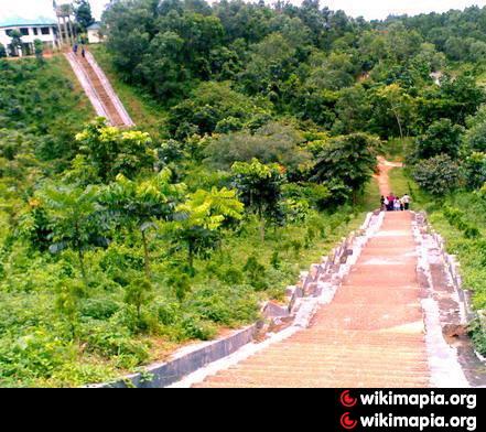
In the Upazila, the biggest attraction is a tourist spot at a place 15 km north of town situated in the middle of the forest at the foot of Garo hills bordering India. A lake has been created by building a dam in the stream of a fountain, its charm and beauty makes the place mesmerizing and an ideal place for travel and picnic. Beside above, there are other spots of attraction in the hill range too. A two storied rest house at the top of the hill built by Parjatan Corp. for rest and recreation. 'Gajni area' being at the very end of Bangladesh border no one is allowed to stay there after 5 pm. There is a watchtower 60 ft high from where the scenic beauty of hills and mountain range of Meghalay (India) can be seen. There is also a 150 meter long tunnel down the hills and its dragon face entrance makes one feel like entering into the dragon’s stomach for real. To visit this magnificent natural park one has to go by road from Sherepur. Sherpur to Gajni is just 45 min. ride by bus or taxi. To enter Gajni area, an entry fee of Tk.150 is charged at Jhenaigati town. The next stoppage will be at a BGB check post for registration of name/names where the border guard officials will give guidelines how far deep one may travel and the places which are out of bounds.
Jhenaigati (Town) consists of 2 mouzas. The area of the town is 1.78 sq km. It has a population of 4304; male 50.91%, female 49.09%. The density of population is 2417 per sq km. Literacy rate among the town people is 36.5%.
Jhenaigati thana was established in 1975 and was turned into an upazila in 1983. The upazila consists of four union parishads, 75 mouzas and 87 villages.
Population 139732; male 51%, female 49%; Muslim 82%, Hindus 8%, Christians 10%; Garo and Hajong ethnic nationals 1072 families.
Main occupations Agriculture 48.21%, commerce 7.73%, service 2.19%, agricultural labourer 27.36%, fishing and carpenter 2.36%, wage labourer 2.05%, transport 1.14% and others 8.42%.
Land use: Total cultivable land 14078.10 hectares; fallow land 2276.01 hectares; single crop 23%, double crop 67% and treble crop land 10%; land under irrigation 78%.
Land control: Among the peasants 32% are landless, 29% small, 27% intermediate and 12% rich; cultivable land per head 0.14 hectare.
Average literacy 17.8%, male 23.5% and female 12.1%. Educational institutions: college 2, high school 16, madrasa 75, government primary school 44, non-government primary school 44, kinder garten school 2, satellite school 25, tailoring college 1. Noted educational institution: Malijikandha High School (1948).
Health centres Upazila health complex 1, family planning centre 7, satellite health centre 1.
Fisheries, dairies, poultries Dairy 11, poultry 12, fishery 21, hatchery 3.
Communication facilities Roads: pucca 37.59 km, semi pucca 3.32 km, mud road 229.97 km.
Manufactories Flour mill 4, oil mill 5, welding 25, saw mill 12, ice factory 8.
Cottage industries: Bamboo work 170, blacksmith 22, goldsmith 32, potteries 57, wood work 20, tailoring 192.
NGO activities Operationally important NGOs are Brac, Asa, Caritas, Grameen bank World Vision, SDS, Rangtia Satata Samchay, Rindan Samity and Didar Sangha.
In the Upazila, the biggest attraction is a tourist spot at a place 15 km north of town situated in the middle of the forest at the foot of Garo hills bordering India. A lake has been created by building a dam in the stream of a fountain, its charm and beauty makes the place mesmerizing and an ideal place for travel and picnic. Beside above, there are other spots of attraction in the hill range too. A two storied rest house at the top of the hill built by Parjatan Corp. for rest and recreation. 'Gajni area' being at the very end of Bangladesh border no one is allowed to stay there after 5 pm. There is a watchtower 60 ft high from where the scenic beauty of hills and mountain range of Meghalay (India) can be seen. There is also a 150 meter long tunnel down the hills and its dragon face entrance makes one feel like entering into the dragon’s stomach for real. To visit this magnificent natural park one has to go by road from Sherepur. Sherpur to Gajni is just 45 min. ride by bus or taxi. To enter Gajni area, an entry fee of Tk.150 is charged at Jhenaigati town. The next stoppage will be at a BGB check post for registration of name/names where the border guard officials will give guidelines how far deep one may travel and the places which are out of bounds.
Nearby cities:
Coordinates: 25°11'10"N 90°4'1"E
- Dhobaura Upazila 28 km
- Gafargaon Upazila 81 km
- Kapashia Upazila 111 km
- Rupganj Upazila 145 km
- Keraniganj Upazila 161 km
- Lohajang Upazila 184 km
- Matlab Upazila (North) Area 194 km
- Patiya Upazila (পটিয়া) 361 km
- Chandanaish Upazila 376 km
- Banshkhali Upazila (বাঁশখালী উপজেলা) 380 km
- Garo Hills in Jhenaigati and Nalitabari, Bangladesh 6.8 km
- Sesengpara 7.6 km
- jhinaigati garo pahar 8.3 km
- Sherpur District 10 km
- Madhu-tila Eco-park- Bangladesh 10 km
- Machangpani 18 km
- Kherapara 22 km
- Nokrek Biosphere Reserve 43 km
- Dhaka Division 120 km
- Meghalaya 133 km