Freedmen's Town (Houston, Texas)
USA /
Texas /
Houston /
Houston, Texas
World
/ USA
/ Texas
/ Houston
World / United States / Texas
place with historical importance, neighborhood, NRHP - National Register of Historic Places, draw only border, historic district
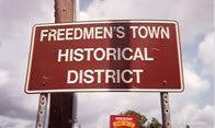
A National Historical District within the Fourth Ward community of Houston, Texas.
A "'freedman's town" in the United States refers to communities built by freedmen, or former slaves who were emancipated during and after the American Civil War).
en.wikipedia.org/wiki/Fourth_Ward,_Houston
A "'freedman's town" in the United States refers to communities built by freedmen, or former slaves who were emancipated during and after the American Civil War).
en.wikipedia.org/wiki/Fourth_Ward,_Houston
Wikipedia article: http://en.wikipedia.org/wiki/Freedmen's_Town
Nearby cities:
Coordinates: 29°45'24"N 95°22'49"W
- Greater Fifth Ward 4 km
- Gulfgate/Pine Valley Super Neighborhood 69 5.3 km
- Denver Harbor/Port Houston (Super Neighborhood 56 7.5 km
- Afton Oaks/River Oaks (SN23) 7.7 km
- Super Neighborhood 22 Washington Ave. Coalition/Memorial Park 8.4 km
- Greater Heights (SN 15) 8.5 km
- Lazy Brook/Timbergrove Super Neighborhood 14 10 km
- Jensen Park 10 km
- Trinity/Houston Gardens Super Neighborhood 48 11 km
- Garden Oaks / Oak Forest (Super Neighborhood 12) 15 km
- Allen Parkway Village 0.3 km
- Allen Center 0.8 km
- Old Sixth Ward National Register Historic District 1 km
- Glenwood Cemetery 1 km
- Buffalo Bayou Park 1.2 km
- Washington Avenue Arts District 1.5 km
- Montrose District 1.9 km
- Downtown Houston 2 km
- Buffalo Bayou Park-Downtown Sector 2.1 km
- Harris County, Texas 10 km