Capsized Ship "Green Coast"
Angola /
Luanda /
World
/ Angola
/ Luanda
/ Luanda
World / Angola / Luanda / Viana
ship, shipwreck, invisible
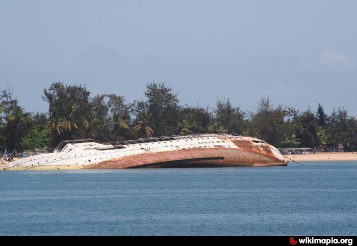
The passenger ship Green Coast (4,992-gt, ex Litva) which lies capsized in Luanda Harbour, has been an unwanted resident since 2001 when a Hong Kong-based company attempted to convert it into a floating hotel. The ship was later the subject of an inquiry by the International Transport Federation (ITF) which accused the owners of holding Chinese workers on board in conditions little different from slavery. The project was later abandoned.
In early 2006 the ship capsized after firefighters pumped too much water on board while trying to extinguish a fire. Luanda authorities have since issued a tender for the righting and removal of the wreck.
The wreck of Green Coast (Litva) would have little more than passing interest were it not one that she is one of the last of the once numerous Soviet Mikhail Kalinin class of passenger ships, having been built in 1960 for Black Sea Shipping.
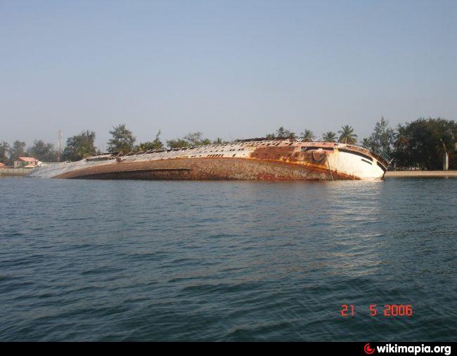
The photograph #2 was taken by Bureau Veritas’ (BV) director in Luanda, Rui Fonseca and made available courtesy of Alex Gregg-Smith of the Durban BV office via Prof Trevor Jones for Ports & Ships News Section ports.co.za/news/article_2006_11_13_2540.html.
In early 2006 the ship capsized after firefighters pumped too much water on board while trying to extinguish a fire. Luanda authorities have since issued a tender for the righting and removal of the wreck.
The wreck of Green Coast (Litva) would have little more than passing interest were it not one that she is one of the last of the once numerous Soviet Mikhail Kalinin class of passenger ships, having been built in 1960 for Black Sea Shipping.
The photograph #2 was taken by Bureau Veritas’ (BV) director in Luanda, Rui Fonseca and made available courtesy of Alex Gregg-Smith of the Durban BV office via Prof Trevor Jones for Ports & Ships News Section ports.co.za/news/article_2006_11_13_2540.html.
Nearby cities:
Coordinates: 8°45'57"S 13°15'35"E
- MV Dunedin Star 1058 km
- Location of oil spill estimates of the missing Indonesian submarine KRI Nanggala 402 11146 km
- Wreck of HIJMS Nojima 14736 km
- Wrecks of Aiyo, Kenbu, Shin-ai and Taimei Maru's 14737 km
- Wreck of Oigawa Maru 14747 km
- Wreck of Teiyo Maru 14748 km
- Healy Volcano 14940 km
- Brothers Volcano 14956 km
- Wreck of HIJMS Kirishima (霧島) 15819 km
- RMS Niagara(wreck) 17431 km
- Angolan Naval Base 2.3 km
- Luanda OLT 2.7 km
- 5M Terminal 2.9 km
- Sonils 3.2 km
- Sonangol P&P Base 1 3.3 km
- Sonangol P&P Base 2 3.3 km
- FKIA - FMC Technologies, Angola 3.6 km
- Halliburton 3.7 km
- Port of Luanda 3.9 km
- Sogester Terminal 3.9 km