Porticus Aemilia (Rome)
Vatican City /
Rome
World
/ Vatican City
/ Vatican City
/ Vatican City
World / Italy / Lazio / Roma
building, monument, archaeological site, Roman Empire, invisible

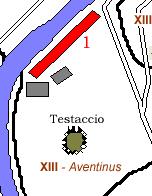
Closely linked to the late 3rd c. BC river port built south of the Aventino hill, the Porticus Aemilia was a vast complex of warehouses situated in the area behind the Emporium or a market for wares.
After about 20 years, this area was further finished off in 174 BC and the enlargement of the Porticus was completed as well. As indicated by the blueprint documented at the Forma Severiana and discoveries made during excavation, it was the largest commercial building built by the Romans.
Parallel to the Tiber, and resembling a large shed (487 m long and 60 m wide), the portico was divided inside by 294 pilasters into seven longitudinal naves (two sloping down towards the river) and fifty transversal naves, covered by a series of vaults perpendicular to the facade.
Still visible between via Rubattino and via Franklin, the imposing structures offer a partial idea of the building’s original grandeur. The walls of volcanic rock, with their corners and archivolts executed in regular tuff blocks, give an example of the earliest of this type of building methods used in Rom
Nearby cities:
Coordinates: 41°52'50"N 12°28'27"E
- Baths of Caracalla 1.3 km
- Main complex 1.4 km
- Trigarium 2.3 km
- Villa Gordiani 6.5 km
- Appio Claudio Park 7 km
- Villa di Livia - archaeological excavation 14 km
- Hadrian's Villa 26 km
- Temple of Ercole Vincitore (=Winner Hercules) 28 km
- Park of the Monsters of Bomarzo 71 km
- Polish cemetery at Monte Cassino 119 km
- Trastevere 1.3 km
- Gianicolo 1.6 km
- Marconi 1.6 km
- Quartiere Garbatella 2.1 km
- Ostiense 2.4 km
- Villa Doria Pamphili 2.6 km
- Rome historical centre 2.6 km
- Portuense 3.1 km
- Ardeatino 4.5 km
- Municipio Roma XI 7.7 km