Ponte Cestio (Rome)
Vatican City /
Rome /
Ponte Cestio
World
/ Vatican City
/ Vatican City
/ Vatican City
World / Italy / Lazio / Roma
Roman Empire, road bridge


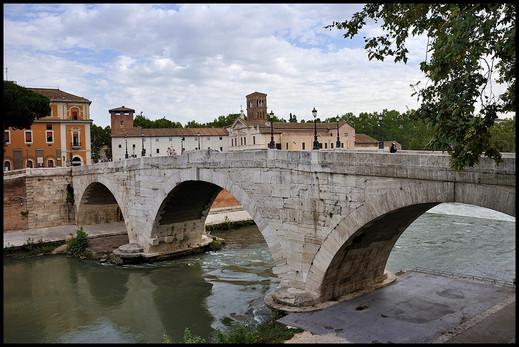
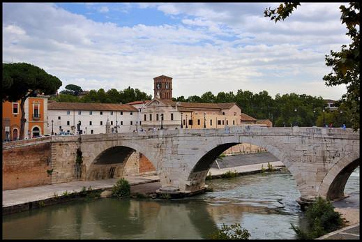
The Pons Cestius is the first bridge that reached the right bank of Tiber from the Tiber Island. Whereas the island was long connected with the left bank of the Tiber and the heart of ancient Rome, even before the pons Fabricius, the right bank (Transtiber) remained unconnected until the Cestius was constructed. It was built around the first century BC (some time between 62 and 27 BC), after the Pons Fabricius, sited on the other side of island.
During the building of the walls along the river embankment in 1888 — 1892, the bridge had to be demolished and rebuilt, as the western channel was widened from 48 to 76 meters. The ancient bridge, which had two small arches, was simply not long enough. A new bridge, with three large arches, was constructed in its stead, with its central arch reusing about two-thirds of the original material.
During the building of the walls along the river embankment in 1888 — 1892, the bridge had to be demolished and rebuilt, as the western channel was widened from 48 to 76 meters. The ancient bridge, which had two small arches, was simply not long enough. A new bridge, with three large arches, was constructed in its stead, with its central arch reusing about two-thirds of the original material.
Wikipedia article: http://en.wikipedia.org/wiki/Pons_Cestius
Nearby cities:
Coordinates: 41°53'24"N 12°28'38"E
- Ancient Ostia (Ostia Antica) 22 km
- Hadrian's Villa 25 km
- Archaeological site of Carsulae 84 km
- Salona 375 km
- Site of the Ancient Roman City of Altinum 408 km
- Roman Rd Via Annia 410 km
- Roman Rd Via Cloudia Augusta 421 km
- Roman Rd Via Annia 423 km
- Virunum 557 km
- Viminacium 775 km
- Sant'Angelo 0.3 km
- The Jewish Ghetto 0.4 km
- Campitelli 0.6 km
- Ripa 0.7 km
- Regola 0.7 km
- Trastevere 0.8 km
- Aventine Hill 0.9 km
- Sant'Eustachio 0.9 km
- Gianicolo 1.1 km
- Rome historical centre 1.5 km