USAF Survivable Low Frequency Communications System Site, Hawes (site)
USA /
California /
Lenwood /
World
/ USA
/ California
/ Lenwood
World / United States / California
military, communication -to be cleaned / removed, interesting place
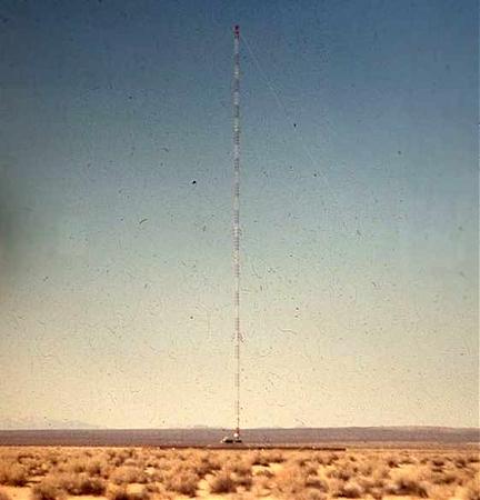

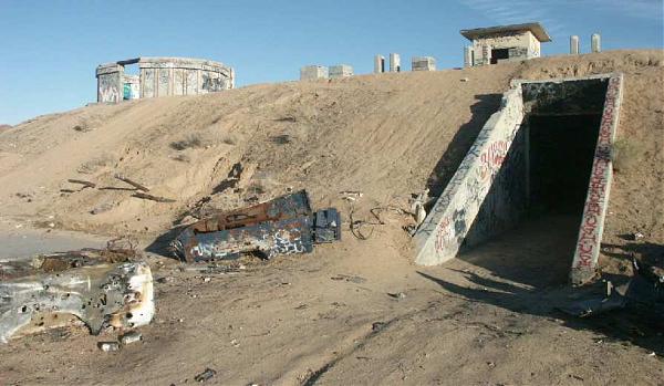
Former site of a solid-state transmitter station and tower site. It was built in the 1960s following the closure of Hawes Army Airfield. Hawes Radio Tower was a mast radiator insulated against ground, which provided VLF communication to ground and mobile nuclear missile facilities during the Cold War. It was over 1,200 feet tall and could be accessed via an internal elevator. It transmitted at a maximum power of 100 kW, transmitting data at 5 & 10 characters per second. The facility was partially built into the ground and was designed to withstand a moderate nuclear blast from a distance of 10 miles. The facility was self-sustaining and employed a sophisticated ventilation system as well as backup diesel generators.
The system was a backup for launching the ICBMs that were controlled by Strategic Air Command. An identical transmitter site was located in Nebraska. Another transmitter was located aboard the flying command post, "Looking Glass."
The radio relay site was closed in 1985 with the tower being demolished with explosives the following year. Following the January 5, 2008 execution-style shootings of two teens in the former bunker, the bunker was destroyed by the BLM and US Air Force in April-May 2008.
www.globalsecurity.org/wmd/systems/slfcs.htm
www.airfields-freeman.com/CA/Airfields_CA_PalmdaleN.htm...
www.militaryphotos.net/forums/showthread.php?t=124090&p...
Wikipedia article: http://en.wikipedia.org/wiki/Hawes_Radio_Tower
Nearby cities:
Coordinates: 34°55'2"N 117°22'36"W
- Edwards AFB / Dryden Flight Research Center (EDW/KEDW) 49 km
- Edwards Air Force Base 71 km
- Palmdale Regional Airport/United States Air Force Plant 42 75 km
- Desert Warfare Training area 82 km
- Marine Corps Air Ground Combat Center Twentynine Palms 82 km
- Fort Irwin National Training Center 83 km
- Naval Air Weapons Station China Lake, South Range 98 km
- Range 500 145 km
- Naval Air Weapons Station China Lake, North Range 154 km
- Targets for Red Flag exercises 251 km
- Mojave Solar Project 12 km
- Harper Dry Lake 16 km
- Hinkley, California 17 km
- Grass Valley Wilderness Area 42 km
- Cuddeback Air to Ground Gunnery Range 42 km
- West Superior Lake 43 km
- East Superior Lake 48 km
- Coyote Lake 60 km
- Goldstone Deep Space Communications Tracking Station 67 km
- Naval Air Weapons Station China Lake, South Range 71 km
Comments