Harper Dry Lake
USA /
California /
Lenwood /
World
/ USA
/ California
/ Lenwood
World / United States / California
marsh, dry lake
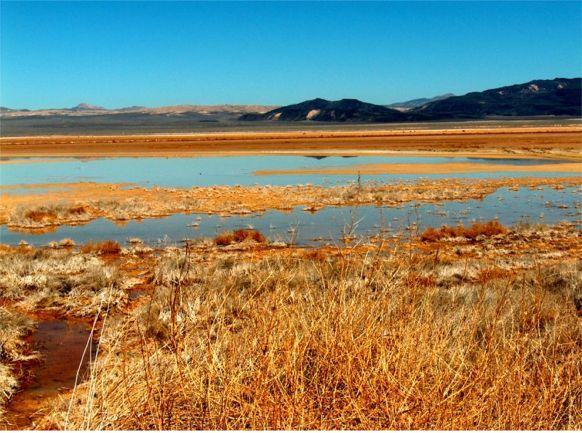
Harper Dry Lake and Marsh, located at the edge of one of the largest dry lakebeds in the Mojave Desert, is an important resting site for thousands of migrating birds. This Watchable Wildlife viewing area is also an Area of Critical Environmental Concern.
The marsh at Harper Dry Lake is not the size it was a century ago. Nonetheless, this small desert oasis consistently attracts resident wetland birds, migratory waterfowl, shorebirds, and many birds of prey.
The marsh at Harper Dry Lake is not the size it was a century ago. Nonetheless, this small desert oasis consistently attracts resident wetland birds, migratory waterfowl, shorebirds, and many birds of prey.
Wikipedia article: http://en.wikipedia.org/wiki/Harper_Lake
Nearby cities:
Coordinates: 35°1'56"N 117°16'27"W
- Staten Island 523 km
- Tyler Island 527 km
- Andrus Island 528 km
- Sherman Island 533 km
- Grand Island 535 km
- Grizzly Island 553 km
- Suisun Marsh 562 km
- Upper Chewaucan Marsh 901 km
- Paulina Marsh 971 km
- Lake Thompson 1976 km
- Mojave Solar Project 4.9 km
- Hinkley, California 14 km
- Grass Valley Wilderness Area 29 km
- Cuddeback Air to Ground Gunnery Range 31 km
- Superior Valley Range simulated airfield target & AAA sites 33 km
- Coyote Lake 49 km
- Goldstone Deep Space Communications Tracking Station 51 km
- Naval Air Weapons Station China Lake, South Range 57 km
- Desert Warfare Training area 68 km
- Fort Irwin National Training Center 71 km
Mojave Solar Project
Hinkley, California
Grass Valley Wilderness Area
Cuddeback Air to Ground Gunnery Range
Superior Valley Range simulated airfield target & AAA sites
Coyote Lake
Goldstone Deep Space Communications Tracking Station
Naval Air Weapons Station China Lake, South Range
Desert Warfare Training area
Fort Irwin National Training Center