Chystohalivka
Ukraine /
Kyyivska /
Prypyat /
World
/ Ukraine
/ Kyyivska
/ Prypyat
, 10 km from center (Припьять)
World / Ukraine / Kiev
ghost town
Add category
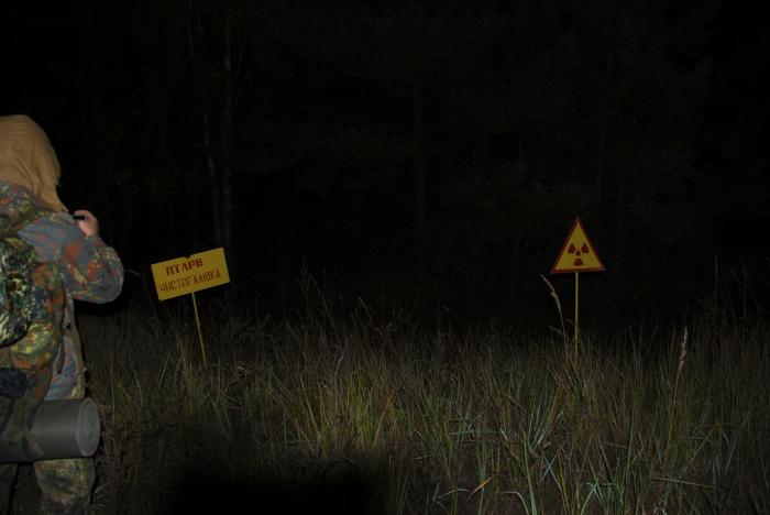


Before accident here was a village Chystohalivka. It was destroyed by building maschines involved in reactor # 4 repairment.
Chystohalivka was a former village in Ukraine, located within the Chernobyl Exclusion Zone (Chernobyl District, Kyiv Oblast).
The village was situated halfway between Stari Shepelychi and Korohod, 22 km from the city of Chernobyl and approximately 4 km from the Chernobyl Nuclear Power Plant. Chystohalivka is mentioned in literary sources from the mid-19th century.
In the mid-1970s, the village had around 1,000 residents (986 on the eve of the disaster) and a middle school.
Chystohalivka was located near the epicenter of the western radioactive fallout trace from the Chernobyl Nuclear Power Plant. After the evacuation of the civilian population, the village was officially liquidated. Its residents were relocated to the village of Havronshchyna in the Makariv district of Kyiv Oblast. Some families were resettled in Mykolaiv Oblast, while the majority moved to Yareshky (Baryshivka district).
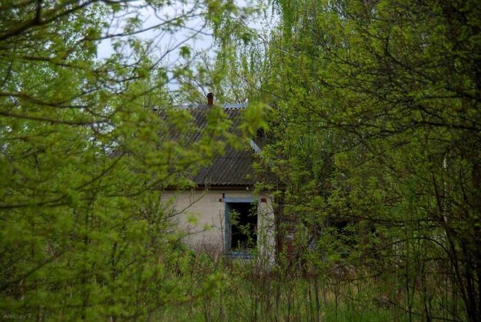
The village's territory was destroyed by wildfires in the Chernobyl Exclusion Zone in April 2020.
The name "Chystohalivka" originates from the Old Slavic phrase "chyste halo," which means "open space" or "clear expanses."
Chystohalivka was a former village in Ukraine, located within the Chernobyl Exclusion Zone (Chernobyl District, Kyiv Oblast).
The village was situated halfway between Stari Shepelychi and Korohod, 22 km from the city of Chernobyl and approximately 4 km from the Chernobyl Nuclear Power Plant. Chystohalivka is mentioned in literary sources from the mid-19th century.
In the mid-1970s, the village had around 1,000 residents (986 on the eve of the disaster) and a middle school.
Chystohalivka was located near the epicenter of the western radioactive fallout trace from the Chernobyl Nuclear Power Plant. After the evacuation of the civilian population, the village was officially liquidated. Its residents were relocated to the village of Havronshchyna in the Makariv district of Kyiv Oblast. Some families were resettled in Mykolaiv Oblast, while the majority moved to Yareshky (Baryshivka district).
The village's territory was destroyed by wildfires in the Chernobyl Exclusion Zone in April 2020.
The name "Chystohalivka" originates from the Old Slavic phrase "chyste halo," which means "open space" or "clear expanses."
Nearby cities:
Coordinates: 51°21'28"N 30°0'39"E
- Chornobyl 15 km
- Tovstyi Lis 17 km
- Denysovychi 28 km
- Martynovychi 31 km
- Novyi Myr 32 km
- Buda-Varovychi 38 km
- Vilcha 44 km
- Poliske 46 km
- Oshytky 54 km
- Chernyn 62 km
- The Red Forest 4.4 km
- Swamp 4.5 km
- Stupnyk Range 4.5 km
- Yanіv 4.8 km
- Korohodskyi Grove 5.6 km
- Korohodskyi Forest 7.9 km
- Stechanka 8.5 km
- Chornobyl Exclusion Zone 8.8 km
- Rozizhdzhe 11 km
- Polesskiy Radiation and Ecological Reserve 28 km
Comments