Portland Harbour
United Kingdom /
England /
Fortuneswell /
World
/ United Kingdom
/ England
/ Fortuneswell
World / United Kingdom / England
water, seaport, breakwater


Portland Harbour is located beside the Isle of Portland, off Dorset, on the south coast of England. It is one of the largest man-made harbours in the world. Grid reference: SY 685 765.
The original harbour was formed by the protection offered by the south coast of England, Chesil Beach and the Isle of Portland. This gave protection from the weather to ships from all directions except the east. King Henry VIII built Portland Castle and Sandsfoot Castle to defend this anchorage.
Construction of the modern harbour began in 1849 when the Royal Navy created a breakwater to the south of the anchorage, made of blocks from local quarries on the Isle of Portland. This was completed in 1872 and created a much larger harbour providing protection from south-easterly winds. The Verne Citadel fort, Nothe Fort, East Wear Battery, High Angle Battery and two forts on the breakwaters were also built.
In 1906, with the threat of torpedo attack from the eastern side of the anchorage, two more breakwaters were added. A further barrier against submarine attack from the south came in 1914 when HMS Hood was scuttled across the southern entrance to the 1848 breakwater.
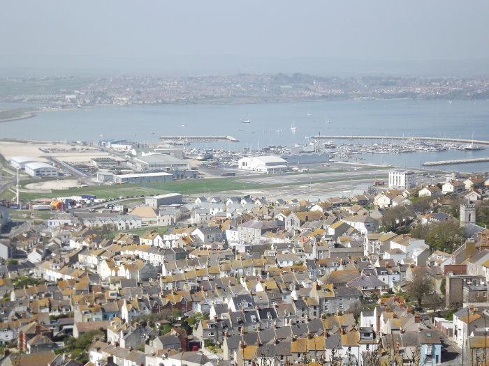
Southern and eastern entrances of Portland Harbour looking northeast. The dark colour of the water between the two breakwaters in the foreground indicates the position of HMS Hood.
The western side of the Harbour with Chesil Beach, Lyme Bay and the Fleet Lagoon in the background.
The harbour is a popular location for wind surfing, diving and sailing, as Weymouth and Portland National Sailing Academy which will host sailing events in the 2012 Olympic Games, is located on the south-western shore of the harbour.
The original harbour was formed by the protection offered by the south coast of England, Chesil Beach and the Isle of Portland. This gave protection from the weather to ships from all directions except the east. King Henry VIII built Portland Castle and Sandsfoot Castle to defend this anchorage.
Construction of the modern harbour began in 1849 when the Royal Navy created a breakwater to the south of the anchorage, made of blocks from local quarries on the Isle of Portland. This was completed in 1872 and created a much larger harbour providing protection from south-easterly winds. The Verne Citadel fort, Nothe Fort, East Wear Battery, High Angle Battery and two forts on the breakwaters were also built.
In 1906, with the threat of torpedo attack from the eastern side of the anchorage, two more breakwaters were added. A further barrier against submarine attack from the south came in 1914 when HMS Hood was scuttled across the southern entrance to the 1848 breakwater.
Southern and eastern entrances of Portland Harbour looking northeast. The dark colour of the water between the two breakwaters in the foreground indicates the position of HMS Hood.
The western side of the Harbour with Chesil Beach, Lyme Bay and the Fleet Lagoon in the background.
The harbour is a popular location for wind surfing, diving and sailing, as Weymouth and Portland National Sailing Academy which will host sailing events in the 2012 Olympic Games, is located on the south-western shore of the harbour.
Wikipedia article: http://en.wikipedia.org/wiki/Portland_Harbour
Nearby cities:
Coordinates: 50°35'4"N 2°26'34"W
- Poole Harbour 31 km
- Port of Southampton 78 km
- Brixham 80 km
- Paignton 83 km
- Chichester Harbour 107 km
- Plymouth 126 km
- Douarnenez 309 km
- Port of Belfast (Calafort Béal Feirste) 509 km
- Thorlakshofn (þorlákshöfn) 1853 km
- Sundahöfn Industrial Zone 1893 km
- Rodwell 2.5 km
- Melcombe Regis 3.5 km
- Westham 3.8 km
- Weymouth Bay 4.3 km
- Isle of Portland 4.7 km
- Radipole 5 km
- Chesil Beach 7.5 km
- Chesil Beach 11 km
- South Dorset Coast SSSI 12 km
- Dorset 25 km