Pattullo Bridge (Surrey, British Columbia)
Canada /
British Columbia /
White Rock /
Surrey, British Columbia
World
/ Canada
/ British Columbia
/ White Rock
World / Canada / British Columbia / Greater Vancouver
bridge
Add category
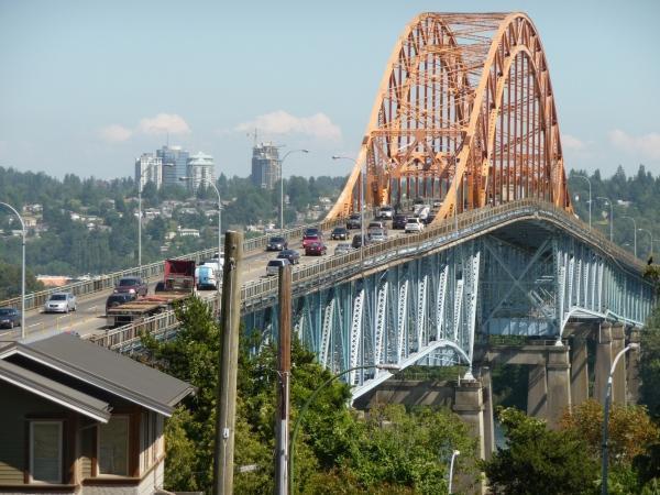
A four lane bridge for automotive traffic. The lanes are very narrow, and there is no divider. It was built in the 1930's to hold only 3 lanes of traffic.
NOTE: pronounced PAH-TOOL-OH, NOT PAH-TULL-OH, which is a common mis pronunciation.
Pattullo Bridge is a compression arch suspended-deck bridge located in the Greater Vancouver Regional District of British Columbia, Canada. Constructed in 1935, it spans the Fraser River and links the city of New Westminster on the north bank of the river to the city of Surrey on the south bank. The bridge forms part of Routes 1A and 99A.
The Pattullo Bridge consists of four lanes (two in each direction) with no barrier of any sort in the centre, making it highly prone to head-on collisions, especially at excessive speed or bad weather. The province and Translink have since closed the middle lanes to traffic from 10:00 p.m. to 5:00 a.m. in an effort to lower the high number of fatal head-on collisions that occur, and installed a series of plastic pillars to raise visibility of the centre lane divider. On January 2, 2006, four people were killed in a T-bone collision between two cars on the southern approach lane.
In response to the high number of crashes that take place on the bridge, Translink is studying the idea of reducing the number of lanes on the bridge from four to three utilizing a counterflow operation. This arrangement is similar to what is being used on the Lions Gate Bridge with the number of lanes being varied depending on traffic flow and volume. A second key and more controversial proposal, is to install photo radar on the bridge to enforce the existing speed limit. Thus far, the provincial government have ruled out the idea of photo radar being brought back.
Its appearance of dark orange colour and arch shape highly resembles the Port Mann Bridge, located just a few kilometers upstream. The bridge was named for Thomas Dufferin Pattullo, former premier of British Columbia.
Wikipedia article: http://en.wikipedia.org/wiki/Pattullo_Bridge
Nearby cities:
Coordinates: 49°12'26"N 122°53'28"W
- New Westminster Bridge 0.6 km
- Port Mann Bridge (old) 5.8 km
- Golden Ears Bridge 16 km
- Oak Street Bridge 17 km
- Granville Street Bridge 20 km
- Mission Bridge 43 km
- Agassiz-Rosedale Bridge 81 km
- Historic Alexandra Bridge Provincial Park 120 km
- Hell's Gate 122 km
- The Myra Canyon - KVR Historic Trestles 265 km
- St. Helen's Park 2.5 km
- Fraser Surrey Docks 3 km
- Port Royal 3 km
- Annacis Auto Terminal 3.5 km
- Queensboro Division sawmill (now closed) 3.6 km
- Former Safeway DC 4.1 km
- Annacis Island 5.6 km
- Ingledow Substation 5.6 km
- Annacis Island Sewage Treatment Plant 6.4 km
- North Delta 8.3 km
Comments