MacArthur Bridge (St. Louis, Missouri)
USA /
Illinois /
Sauget /
St. Louis, Missouri
World
/ USA
/ Illinois
/ Sauget
World / United States / Illinois
bridge
Add category
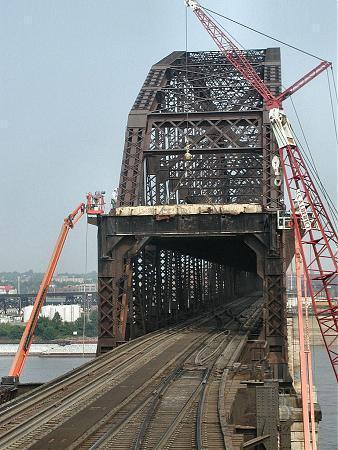


Operated by the Terminal Railroad Association of St. Louis railroad, and also used by Amtrak. Upper level carried automobile traffic, but closed many years ago.
bridgehunter.com/mo/st-louis-city/macarthur/
bridgehunter.com/mo/st-louis-city/macarthur/
Wikipedia article: http://en.wikipedia.org/wiki/MacArthur_Bridge_(St._Louis)
Nearby cities:
Coordinates: 38°36'53"N 90°11'2"W
- Stan Musial Veterans Memorial Bridge 3.7 km
- Merchants Bridge 6.9 km
- Jefferson Barracks Bridge 16 km
- New Chain of Rocks Bridge 17 km
- Chain of Rocks Bridge 17 km
- Blanchette Bridge 31 km
- Veterans Memorial Bridge 33 km
- Discovery Bridge 33 km
- Wabash Bridge (St. Charles, Missouri) 33 km
- Washington Bridge (Washington, Missouri) 71 km
- Lasalle Park 1.6 km
- Downtown St. Louis 2 km
- Soulard 2.3 km
- Benton Park Neighborhood 3.4 km
- Benton Park West Neighborhood 4.6 km
- Tower Grove East 4.8 km
- Gravois Park Neighborhood 5.2 km
- Historic Shaw Neighborhood 5.6 km
- Tower Grove Park 6.3 km
- Carondelet Park 9 km
Comments