Hrabivske Reservoir
Ukraine /
Luhanska /
Sadovo-Khrustalnenskyy /
World
/ Ukraine
/ Luhanska
/ Sadovo-Khrustalnenskyy
, 5 km from center (Садово-Хрустальненський)
World / Ukraine / Donets'k
fishing area, reservoir


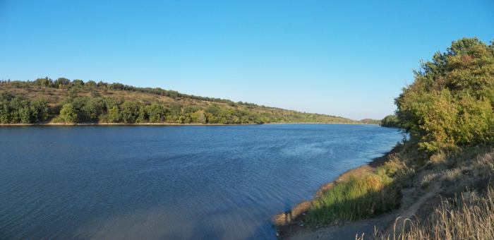


The Hrabivske Reservoir is located in the Shakhtarsk Raion (district) of the Donetsk Oblast (region) of Ukraine, near the borders with the Luhansk Oblast (region) of Ukraine.
It was formed about 50 years ago, as a result of the flooding of the deep and narrow Hrabove gully by the waters of the small Mius River.
The main purpose of the reservoir was to regulate the flow of water in the river, as well as provide the steppe and arid northeastern region with water resources.
The dimensions of the reservoir:
area: 40 hectares
depth: 22 m, in some places up to 40 m
The Hrabivske reservoir is located in the most beautiful corner of nature – the Hrabove tract, which is known as a botanical natural monument of national importance.
The reservoir is surrounded on all sides by a forest, the main part of the trees is hornbeam.
The banks of the reservoir are steep, rocky and precipitous from the side of the Donetsk region, and from the Luhansk are gently sloping muddy banks.
The reservoir has about ten bays covered with thickets of reeds.
Various types of algae grow in the water.
Various species of waterfowl nest along the banks, small and steppe game live in the forests. Fishermen come to the reservoir both in summer and winter.
There are fish in the waters of the reservoir: carp, grass carp, perch, crucian carp, silver carp, rudd, catfish, carp, chub, ruff, roach.
Nearby cities:
Coordinates: 48°8'52"N 38°40'59"E
- Yanivske reservoir 5 km
- Yelizavetynske reservoir 32 km
- Platonivske Reservoir 51 km
- Kleban-Byk reservoir lake 82 km
- Novooleksiivskyi Pond 120 km
- Pond 152 km
- Fedorivskyi Pond 157 km
- Private Pond 202 km
- Pond 236 km
- Pond 329 km
- Pivnichna Bay 0.3 km
- Dovzhyk Arroyo 2.2 km
- Hrabivska filtering station 2.8 km
- Spillway 2.8 km
- Balka Try Duby (Three Oaks ravine) 3.1 km
- Korchi 4.6 km
- Pond 5.1 km
- Yanivske reservoir 5.5 km
- Hlukha Balka arroyo 5.8 km
- Hlukhivskyi forest 6.1 km