Schuldturm (debtors' tower) (Nuremberg)
Germany /
Bayern /
Nuremberg
World
/ Germany
/ Bayern
/ Nuremberg
World / Germany / Bayern / Mittelfranken
historical layer / disappeared object
Add category
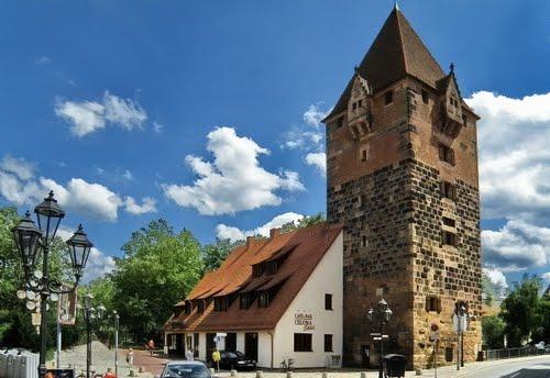
The Schuldturm (debtors' tower) was part of the first citywall of medieval Nuremberg (erected in 1320). When a second, wider citywall was built the tower was further used to emprison people who could or would not pay their taxes.
Today it is a restaurant.
Today it is a restaurant.
Nearby cities:
Coordinates: 49°27'9"N 11°4'51"E
- Ultrastrenggeheimes Munitionslager 103 km
- Former East West German Border 128 km
- Former Muna Wildflecken 132 km
- Siegelsbach Army Depot (former military base) 149 km
- EDEC Aschaffenburg AAF (US Army Airfield) 152 km
- Conversion area (Former Rhein-Main Air Base) 194 km
- Ticona 198 km
- Eichkopf Truppenübungsplatz (U.S. Army) 202 km
- Roman Way Village (U.S. Army) 206 km
- Ayers Kaserne "the Rock" at Kirch-Göns 210 km
- Hauptmarkt 0.3 km
- GALERIA Nürnberg an der Lorenzkirche 0.3 km
- Altstadt 0.3 km
- Germanisches Nationalmuseum 0.6 km
- Tafelhof Palais 0.7 km
- Nuremberg central railway station 0.7 km
- Erfahrungsfeld zur Enfaltung der Sinne 0.8 km
- Wöhrder Wiese 0.8 km
- Nuremberg Transport Museum 0.9 km
- Siemens 1.9 km