"Townsend Place" (Oyster Bay Cove, New York)
USA /
New York /
Oyster Bay Cove /
Oyster Bay Cove, New York /
Cove Road, 84
World
/ USA
/ New York
/ Oyster Bay Cove
World / United States / New York
residence, LIGC - Long Island Gold Coast
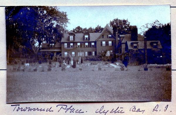
Listed on the 1873 Survey Map. Former estate of Edward M. Townsend.
Townsend Place
Built in 1732, later enlarged,
and sold in 1938-1939, torn down in the early 90s.
archive.org/details/prominentresiden1916newy/page/138/m...
Townsend Place
Built in 1732, later enlarged,
and sold in 1938-1939, torn down in the early 90s.
archive.org/details/prominentresiden1916newy/page/138/m...
Nearby cities:
Coordinates: 40°52'22"N 73°30'54"W
- "Northwood" II 0.9 km
- Sunken Orchard Estate Lands 1.7 km
- "Redcote" 2.2 km
- "Dolonar" 2.3 km
- Mill River at Upper Brookville Development 3.4 km
- Mill Neck Manor School for the Deaf 4.2 km
- "Farnsworth" (demolished) 4.5 km
- Eastover Farm 4.5 km
- Planting Fields Arboretum State Historic Park 4.6 km
- 'Applegarth' 4.7 km
- Oyster Bay, New York 1.7 km
- Cold Spring Harbor 3.1 km
- West Neck 5.8 km
- Syosset, New York 6.1 km
- Town of Huntington 11 km
- Town of North Hempstead 15 km
- Nassau County, New York 15 km
- Westchester County, New York 33 km
- Long Island Sound 39 km
- Suffolk County, New York 71 km