Raninagar Upazila HQ
Bangladesh /
Naugaon /
World
/ Bangladesh
/ Naugaon
/ Naugaon
World / Bangladesh / Rajshahi / Rajshahi / Naogaon
township, subdistrict, fourth-level administrative division, local government
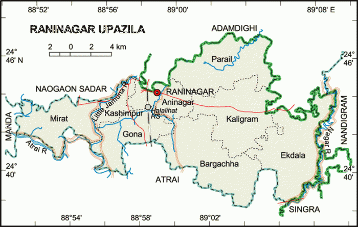

Raninagar Upazila (Naogaon district) with an area of 258.33 sq km, is bounded by Naogaon sadar and Adamdighi upazilas, Atrai upazila on the south, Nandigram and Singra upazilas on the east, Manda upazila on the west. Main river is Jamuna.
The location of the Raninagar town is 24.7378775N 88.9667307E. Raninagar (Town) consists of one mouza. The area of the town is 0.1 sq km. The population of the town is 4757; male 51%, female 49%. Literacy rate among the town people is 34.2%. It has one dakbungalow and one railway station.
Raninagar thana was established in 1916 and was turned into an upazila in 1983. It consists of 8 union parishads, 169 villages and 191 mouzas.
As of the 1991 Bangladesh census, Population 158244; male 50.94% and female 49.06%. Muslim 86.6%, Hindu 13% and others 0.4%; noted ethnic nationals: Oraon.
Literacy and educational institutions Average literacy 27.9%; male 35.2% and female 20%. Educational institutions: college 3, secondary school 16, primary school 82 and madrasa 15, NGOs operate primary school 85, others institution 18.
eligious institutions Mosque 276 and temple 17.
Land use Agricultural land 21627 hectares; single crop 30%, double crop 55% and treble crop land 15%. Land under irrigation 66%.
Land control Among the peasants, 37% are landless, 22% small, 31% marginal and 10% rich.
Value of land The market value of land of first grade is about Tk. 6000 per 0.01 hectare.
Main occupation Agriculture 51.92%, fishing 2.04%, agricultural labourer 23.39%, wage labourer 1.13%, industry 1.45%, commerce 9.36%, service 2.5%, others 8.21%.
Dairies, poultries and fisheries Dairy 13, poultry 55, hatchery 11.
Communication facilities Roads: pucca 25 km, semi pucca 5 km and mud road 55 km, railway 7 km.
Manufactories 57 including ice factory, boiler and biscuit factory.
Cottage industries Mats product 44, weaving 41.
NGO activities Operationally important NGOs are brac, CARE, asa, Ujjiban.
Health centres Upazila health complex 1, union health and family planning centre (RD) 6, union family welfare centre (FWC) 3.
Nearby cities:
Coordinates: 24°44'18"N 88°58'40"E
- Gobindaganj Upazila 60 km
- Shaghatta Upazila 76 km
- Sarishabari Upazila 77 km
- Bholahat Upazila HQ 83 km
- Abhaynagar Upazila HQ 191 km
- Fakirhat Upazila HQ 227 km
- Kachua Upazila HQ 247 km
- Koyra Upzila HQ 264 km
- Maidi Vdc 551 km
- Samote Union Council 1789 km
- Ilshabari Village, Naogaon Sadar, naongon. 3.3 km
- Taratia 8.2 km
- keashorota,adamdighi.dogra 10 km
- Bagbari, Chhatiangram, (UJ: Adamdighi), Dist: Bogra 11 km
- Kadoa Village 12 km
- Shalgram 13 km
- Venlla, Adomdighi, Bagora. Shanto-Rustom 14 km
- Altafnagar 18 km
- Chalan Beel of Natore Area 25 km
- Rajshahi Division 53 km