Abhaynagar Upazila HQ
Bangladesh /
Jessor /
Abhaynagar /
World
/ Bangladesh
/ Jessor
/ Abhaynagar
World / Bangladesh / Khulna / Jessore / Jessore
township, subdistrict, fourth-level administrative division, local government

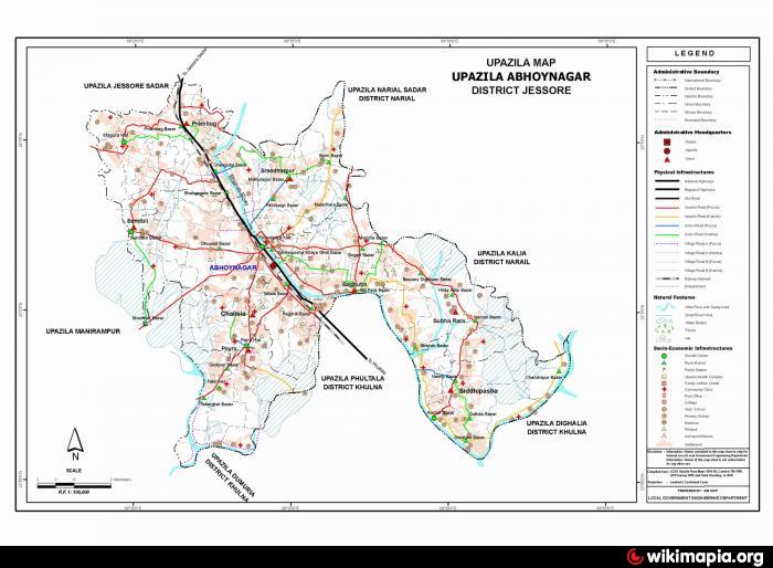
Abhaynagar Upazila (Jessore district) with an area of 247.19 sq km is bounded by Jessore Sadar upazila on the north, Dumuria, Khan jahan ali, Dighalia and Phultala upazilas on the south, Narail sadar and Kalia upazilas on the east and Jessore Sadar and Manirampur upazilas on the west. Main river is Bhairab; tank 7; baor 6. Singra, beel dakatia and Kurakhali beel are notable.
The location of the Abhaynagar town is 23.0264132N 89.4014973E. Abhaynagar (Town) consists of three mouzas. The area of the town is 10.34 sq km. It has a population of 28597; male 53.67%, female 46.33%; density of population is 1895 per sq km. Literacy rate among the town people is 39%. The town has one dukbangalow.
Abhaynagar upazila consists of 8 unions, 89 mouzas and 121 villages.
As of the 1991 Bangladesh census: Population 245000; male 51.84%, female 48.16%; Muslim 76.21%; Hindu 23.63% and others 0.16%.
Religious institutions: Mosque 227, temple 66, church 2, tomb 3 and sacred place 2.
Literacy and educational institutions: Average literacy 39.9%; male 53.2% female 26.5%. Educational institutions: college 6, high school 30, junior school 16, madrasa 34, primary school 206, technical educational institute 1.
Cultural organisations: Club 22, public library 2, theatre group 7, theatre stage 1, cinema hall 3, literary society 3, playground 32.
Main occupations: Agriculture 31.48%, agricultural labourer 17.16%, wage labourer 4.11%, commerce 12.32%, service 22.04%, fishing 1.49%, industry 1.2%, transport 1.93% and others 8.27%.
Land use: Total cultivable land 18388 hectares; fallow land 1540 hectares; single crop 22%, double crops 42% and treble crops 36%; cultivable land under irrigation 56.87%.
Land control: Among the peasants 23% are landless, 12% small, 33% intermediate and 32% rich.
Fisheries, dairies, poultries Poultry 120, dairy 35, hatchery 6, fishery 30.
Communication facilities- Roads: pucca 46.59 km, semi pucca 25.92 km and mud road 300.24 km; waterways 15 km; railways 13 km.
Manufactories: Jute mill 4, textile mill 4, leather factory 2, salt factory 2, rice mill 78, ice factory 7, cement factory 7.
Cottage industries: weaving 12, goldsmiths 28, potteries 30, welding 45.
NGO activities: Operationally important NGOs are Palli Unnayan, Ashar Alo Sangstha, brac, CARE, RRC,grameen bank.
Health centres: Upazila health complex 1, Union health and family planning centre 8, Satellite clinic 3.
Nearby cities:
Coordinates: 23°2'7"N 89°23'40"E
- Fakirhat Upazila HQ 39 km
- Kalaroa Upazila HQ 42 km
- Kachua Upazila HQ 62 km
- Koyra Upzila HQ 74 km
- Sarishabari Upazila 203 km
- Shaghatta Upazila 246 km
- Gobindaganj Upazila 246 km
- Bholahat Upazila HQ 247 km
- Maidi Vdc 717 km
- Samote Union Council 1940 km
- Nowapara Bazar 2.5 km
- Lake 3.4 km
- Singari - Birth Place of Freedom Fighter Principal (Retired) Sheikh Abdul Wahab MP 6.5 km
- OXFORD OF 96 VILLAGES: A CLUSTER OF EDUCATIONAL INSTITUTIONS 7.7 km
- Bokorh Bil 7.8 km
- Chakoy 8.1 km
- PANCH KATIA 10 km
- PROTAPKATI 11 km
- Bil Dakatiya 14 km
- Khulna Division 16 km