Kurtz's Mill Covered Bridge (Lancaster, Pennsylvania)
USA /
Pennsylvania /
Lancaster /
Lancaster, Pennsylvania
World
/ USA
/ Pennsylvania
/ Lancaster
World / United States / Pennsylvania
covered bridge
Add category
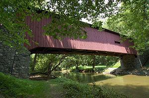


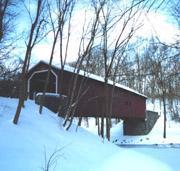
Kurtz's Mill Covered Bridge is a covered bridge that spans Mill Creek in the Lancaster County Park in Lancaster County, Pennsylvania. The bridge has a single span, wooden, double burr arch trusses design with the addition of steel hanger rods. The bridge is accessible to road traffic. The bridge was built in 1876 by W. W. Upp over the Conestoga River. In 1972, it was damaged by the floodwaters caused by Hurricane Agnes. It was repaired in 1975 and moved to its present location over Mill Creek, a tributary of the Conestoga River. Length: 94 feet (28.7 m) span and 90 feet (27.4 m) total length.
Wikipedia article: http://en.wikipedia.org/wiki/Kurtz's_Mill_Covered_Bridge
Nearby cities:
Coordinates: 40°0'54"N 76°16'56"W
- Pennsylvania Railroad Bridge (Ruins/Demolished) 21 km
- Conowingo Bridge (Former Site) 38 km
- Port Deposit Bridge remnants 46 km
- Abandoned Bridge Piers 145 km
- Restored Covered Bridge & Park 746 km
- Shadyside Recreation Area 800 km
- Bell Ford Bridge 836 km
- Clearbranch Methodist Baptist Church and Covered Bridge 1151 km
- Bollinger Mill State Historic Site 1210 km
- Covered Bridge Park 1568 km
- Lancaster County Central Park 0.5 km
- Lancaster County, Pennsylvania 1.3 km
- Lyndon, Pennsylvania 1.7 km
- Willow Street, Pennsylvania 3.9 km
- Lampeter, Pennsylvania 4.4 km
- Greenfield Industrial Park 4.8 km
- Strasburg, Pennsylvania 9 km
- Cherry-Crest Adventure Farm 13 km
- Paradise, Pennsylvania 13 km
- Amtrak/PRR 25Hz Power Transmission Lines 31 km