Devils Postpile
USA /
California /
Mammoth Lakes /
World
/ USA
/ California
/ Mammoth Lakes
World / United States / California
formation, cliff, geography, interesting place, draw only border
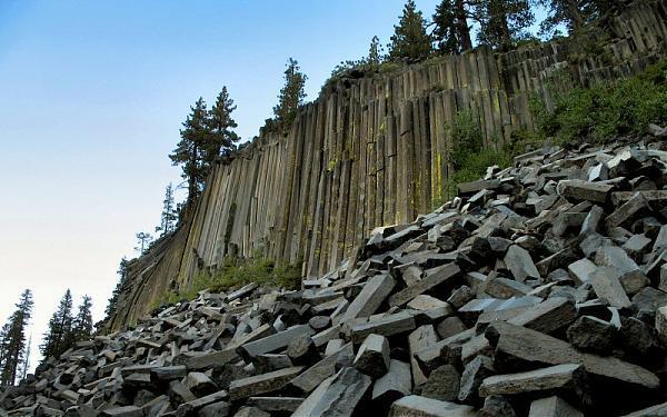
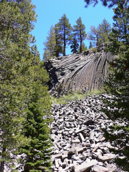
Devils Postpile is a dark cliff of columnar basalt near Mammoth Mountain in eastern California. The postpile was created by a lava flow sometime between less than 100,000 years ago (according to current potassium-argon dating) to 700,000 years ago (according to other dating methods). The source of the lava is thought to have been somewhere near Upper Soda Springs campground at the north end of Pumice Flat on the floor of the Middle Fork of the San Joaquin River, from where it flowed to the site of the Postpile, was impounded by a moraine, and reached a thickness of 400 feet (newer estimate) to 600 feet (older estimate). In any event, the lava that now makes up the Postpile was near the bottom of this mass.
www.topoquest.com/map.php?lat=37.62438&lon=-119.08180&d...
www.topoquest.com/map.php?lat=37.62438&lon=-119.08180&d...
Wikipedia article: http://en.wikipedia.org/wiki/Devils_Postpile_National_Monument
Nearby cities:
Coordinates: 37°37'30"N 119°5'6"W
- Alligator Rock 547 km
- Pinnacles 634 km
- Montezuma's Head 844 km
- Sleeping Giant 2706 km
- The 100 hills (Hunderberg) 10048 km
- hajiabad formation 12129 km
- Ubirr 12434 km
- Wilpena Pound 13095 km
- Kata Tjuta / Mount Olga 13416 km
- Amphitheatre (Drakensberg) 16911 km
- Devils Postpile National Monument 1.1 km
- Mammoth Mountain Ski Resort 5.8 km
- Volcanic Ridge 7.6 km
- South Deadman Flow 11 km
- Duck Lake 14 km
- Thousand Island Lake 14 km
- Mammoth Yosemite Airport (MMH/KMMH) 21 km
- Long Valley Caldera 21 km
- Graveyard Lakes 22 km
- Inyo National Forest 72 km