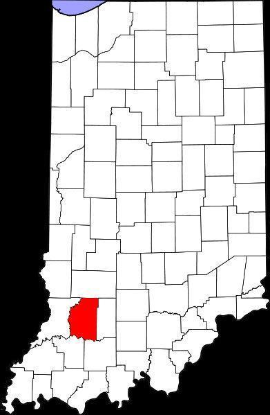
Daviess County, Indiana
USA /
Indiana /
Montgomery /
World
/ USA
/ Indiana
/ Montgomery
World / United States / Indiana
county, draw only border
www.daviesscounty.net/
Daviess County was formed in 1817 out of Sullivan Knox and Orange Counties. It was named for Maj. Joseph Hamilton Daviess, U.S. District Attorney for Kentucky, killed at the Battle of Tippecanoe in 1811. Daviess County, IN is one of two counties of the same name in the Evansville Area, the other being Daviess County, KY (Owensboro, Ky). The main way of telling one form the other is that Daviess County, KY is pronounced ("Davis") while Daviess County, IN is pronounced ("Daveez").
Nearly 650 Old Order Amish families make their homes in Daviess County, Indiana, mainly in central Daviess County, around Montgomery and Odon.
Wikipedia article: http://en.wikipedia.org/wiki/Daviess_County,_Indiana
Nearby cities:
Coordinates: 38°41'50"N 87°5'29"W
- Kanawha County, West Virginia 450 km
- Fulton County, Georgia 541 km
- Greenbrier County, West Virginia 542 km
- Pocahontas County, West Virginia 584 km
- Randolph County, West Virginia 592 km
- Westmoreland County, Pennsylvania 654 km
- Augusta County, Virginia 658 km
- Somerset County, Pennsylvania 682 km
- Rockingham County, Virginia 683 km
- Robeson County, North Carolina 797 km
- Daviess County Airport (KDCY) 3.5 km
- Country Oaks Golf Club 4.5 km
- Interstate 69 Exit 62 5.2 km
- West Boggs Lake 14 km
- Loogootee High School 15 km
- West Boggs Park 15 km
- Glendale Fish & Wildlife Area 17 km
- Dogwood Lake 17 km
- Lark Ranch 20 km
- Crane Naval Surface Warfare Center 30 km
Comments