Louisville-Jefferson County, Kentucky
USA /
Kentucky /
Louisville /
World
/ USA
/ Kentucky
/ Louisville
World / United States / Kentucky
city, county, draw only border, county seat
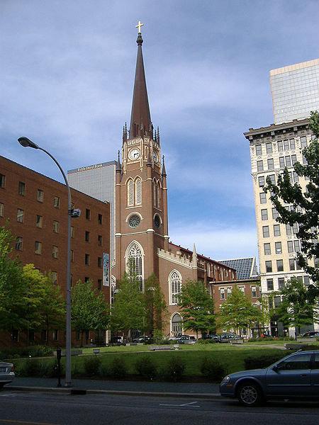
Louisville (pronounced /lo͞o'·ē·vil/; see Pronunciation below) is Kentucky's largest city. It is ranked as either the 17th or 27th largest city in the United States depending on how the population is calculated (see Nomenclature, population and ranking below). The settlement that became the City of Louisville was founded in 1778 by George Rogers Clark and is named after King Louis XVI of France. Louisville is famous as the home of "The Most Exciting Two Minutes in Sports": the Kentucky Derby, the widely watched first race of the Triple Crown of Thoroughbred Racing.
Louisville is situated in north-central Kentucky on the Kentucky-Indiana border at the only natural obstacle in the Ohio River, the Falls of the Ohio. Louisville is the county seat of Jefferson County, and since 2003, the city's borders are coterminous with those of the county due to merger. Because it includes counties in Southern Indiana, the Louisville metropolitan area is regularly referred to as Kentuckiana. A resident of Louisville is referred to as a Louisvillian. Although situated in a Southern state, Louisville is influenced by both Midwestern and Southern culture, and is commonly referred to as either the northernmost Southern city or the southernmost Northern city in the United States.
Louisville has been the site of many important innovations through history. Notable residents have included inventor Thomas Edison, the first Jewish Supreme Court Justice Louis Brandeis, boxing legend Muhammad Ali, newscaster Diane Sawyer, and writer Hunter S. Thompson. Notable events occurring in the city include the first public viewing place of Edison's light bulb, the first library open to African Americans in the South, and medical advances including the first human hand transplant, the first self-contained artificial heart transplant, and the development site of the first cervical cancer vaccine.
Nomenclature, population and ranking
City of Louisville
Population by year
(Pre-merger)
2000 - 256,231
1990 - 269,063
1980 - 298,451
1970 - 361,472
1960 - 390,639
1950 - 369,129
1940 - 319,077
1930 - 307,745
1920 - 234,891
1910 - 223,928
1900 - 204,731
1890 - 161,129
1880 - 123,758
1870 - 100,753
1860 - 68,033
1850 - 43,194
1840 - 21,210
1830 - 10,341
1820 - 4,012
1810 - 1,357
1800 - 359
1790 - 200
As of the 2000 Census, Louisville had a population of 256,231; which for the first time since 1820 was less than the population of Lexington, a city with a consolidated city-county government. However, on November 7, 2000 voters in Louisville and Jefferson County approved their own ballot measure to merge into a consolidated city-county government named Louisville-Jefferson County Metro Government (official long form) and Louisville Metro (official short form), which took effect January 1, 2003. The Jefferson County-Louisville merger has a population more than twice as large as Lexington-Fayette.
The U.S. Census Bureau gives two different population figures for Louisville: for the consolidated Louisville-Jefferson County it lists the 2006 estimated population as 701,500 (17th largest in the nation and equal to that of Jefferson County); for the Louisville-Jefferson County balance it lists the population as 554,496 (27th largest). The "balance" is a designation created by the Census Bureau to describe the portion of Louisville-Jefferson County that does not include any of the semi-independent separately incorporated places located within Louisville Metro (such as Anchorage, Middletown or Jeffersontown). Census methodology uses balance values in comparing consolidated cities to other cities for ranking purposes, so the lower ranking is the figure officially reported by the Census Bureau. Nevertheless, the higher ranking continues to be claimed by Louisville Metro government and business leaders, widely reported in the local media, and it has even been posted on road signs at the city limits.
The Louisville metropolitan area (MSA) (not to be confused with Louisville Metro), has a population of 1,233,735 ranking 42nd nationally. The metro area includes Louisville-Jefferson County and 12 surrounding counties, eight in Kentucky and four in Southern Indiana (see Geography below). The Louisville Combined Statistical Area includes the MSA and three additional counties. It has a total population of 1,369,049, which ranks 31st in the U.S.
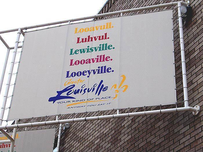
Pronunciation
The Louisville Convention and Visitors Bureau displays many of the common pronunciations of the city's name on its logo.Most native residents pronounce the city's name /ˈluːǝvǝl/ — often this degrades further to /ˈlǝvǝl/ (info). The name is often pronounced far back in the mouth, in the top of the throat. The standard English pronunciation, however, is /lo͞o'·ē·vil/ (referring to King Louis XVI, for whom the city is named), which is often utilized by political leaders and the media. No matter how Louisville is pronounced, the 's' is always silent. (This contrasts with the name of the cities Louisville, Colorado, Louisville, Georgia, Louisville, Mississippi, Louisville, Tennessee and Louisville, Ohio, which, although spelled the same, are pronounced /ˈluːɪsvɪl/ (info).)
The variability of the local pronunciation of the city's name can perhaps be laid at the feet of the city's location on the border between the Northern and Southern regions of the United States. Louisville's diverse population has traditionally represented elements of both Northern and Southern culture.
Regional migration patterns and the homogenization of dialect due to electronic media also may be responsible for the incidence of native-born Louisvillians adopting or affecting the standard English pronunciation. Nevertheless, the ['luːǝvǝl] pronunciation is most popular among residents and is, with few exceptions, used by news and sports reporters.
History
The first European settlement made in the vicinity of modern-day Louisville was on Corn Island in 1778 by Col. George Rogers Clark. Today, Clark is recognized as the founder of Louisville, and several landmarks are named after him.
Two years later, in 1780, the Virginia General Assembly approved the town charter of Louisville. The city was named in honor of King Louis XVI of France, whose soldiers at the time were aiding Americans in the Revolutionary War. Early residents lived in forts due to Indian raids, but were moving out by the late 1780s. In 1803, explorers Meriwether Lewis and William Clark organized their expedition across America at the Falls of the Ohio in Louisville.
The city attributes its early growth to the fact that river boats had to be unloaded and moved downriver before reaching the falls. By 1828, the population had swelled to 7,000 and Louisville became an incorporated city. The city grew rapidly in its formative years.
Louisville had one of the largest slave trades in the United States before the Civil War and much of the city's initial growth is attributed to that trade. Louisville was the turning point for many enslaved blacks since Kentucky, although it was to be a border state in the Civil War, was nevertheless a slave state and crossing the Ohio River could lead to freedom in the North.
During the Civil War Louisville was a major stronghold of Union forces, which kept Kentucky firmly in the Union. It was the center of planning, supplies, recruiting and transportation for numerous campaigns. By the end of the war, Louisville itself had not been attacked even once, even though surrounded by skirmishes and battles. After 1865 returning Confederate veterans largely took control of the city, leading to the jibe that it joined the Confederacy after the war was over.
The first Kentucky Derby was held on May 17, 1875, at the Louisville Jockey Club track (later renamed to Churchill Downs). The Derby was originally shepherded by Meriwether Lewis Clark, Jr., the grandson of William Clark of the Lewis and Clark Expedition. 10,000 spectators were present at the first Derby to watch Aristides win the race.
On March 27, 1890 the city was devastated and downtown nearly destroyed when an F4 tornado tore through the city at 8:30pm as part of the Mid-Mississippi Valley Tornado Outbreak of March 1890. An estimated 74 to 120 people were killed. The city quickly recovered and signs of the tornado were nearly totally absent within a year.
In late January and February of 1937, a month of heavy rain in which 19" fell prompted what became remembered as the "Great Flood of '37". The flood submerged about 70% of the city, power was lost, and it forced the evacuation of 175,000 residents, and also led to fundamental changes in where residents bought houses. Today, the city is protected by numerous flood walls. After the flood, the areas of high elevation in the eastern part of the city saw decades of growth.
Similar to many other older American cities, Louisville began to experience a flight of people and businesses to the suburbs in the 1960s and 1970s. Newly built freeways and interstates helped facilitate this shift. The West End and older areas of the South End in particular began to decline economically as many local factories closed. In 1974 a major (F4) tornado hit Louisville as part of the Super Outbreak of tornadoes that struck 13 states. It covered 21 miles (34 km) and destroyed several hundred homes in the Louisville area but was only responsible for two deaths.
Jefferson County had a population loss of 31,000 from 1970 to 1990, but has since gained 45,000. The population within the old city limits dropped by 134,000 from its peak in 1970, falling from 33rd nationally to 58th, although its population is now stabilizing.
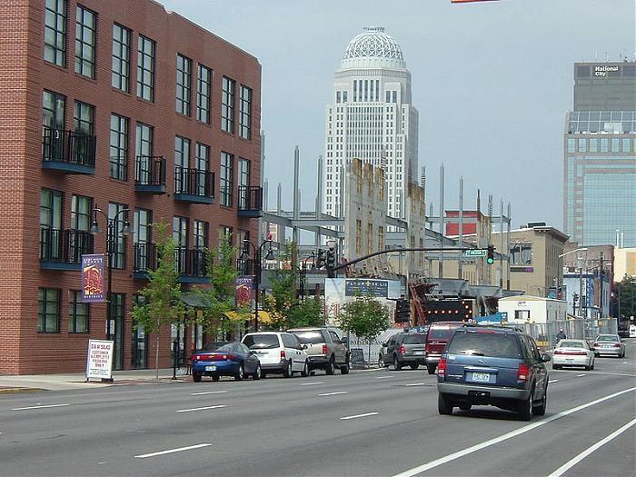
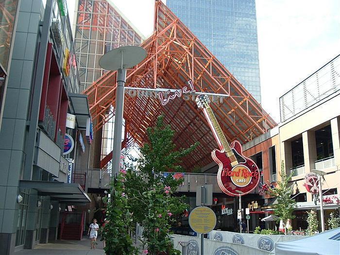
Since the 1980s, many of the city's urban neighborhoods have been revitalized into areas popular with young professionals and college students. The greatest change has occurred along the Bardstown Road corridor, Frankfort Avenue, and the Old Louisville neighborhood. Downtown has also experienced a large amount of growth, including the tripling of its population since 1990, the conversion of waterfront industrial sites into Waterfront Park, and the refurbishing of the former Galleria into the bustling entertainment complex Fourth Street Live!.
Louisville is located at 38°13′44″N, 85°44′58″W (38.228870, -85.749534). According to the U.S. Census Bureau, Louisville Metro (in 2000 measurements for Jefferson County) has a total area of 399 square miles (1,032 km²), of which, 385 square miles (997 km²) of it is land and 13 square miles (35 km²) of it (3.38%) is water.
Geography
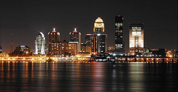
Louisville is located in the Bluegrass region, but the city has a greater affinity for its location on the Ohio River, which spurred Louisville's growth from an isolated camp site into a major shipping port. Much of the city is located on a very wide and flat flood plain surrounded by hill country on all sides. Much of the area was swampland and had to be drained as the city grew. In the 1840s most creeks were rerouted or placed in canals to prevent flooding and subsequent disease outbreaks.
Areas generally east of I-65 are above the flood plain, and are composed of gently rolling hills. The Southernmost parts of Jefferson County are in the scenic and largely undeveloped Knobs region home to Jefferson Memorial Forest.
The Louisville-Jefferson County, KY-IN Metropolitan Statistical Area (MSA), the 42nd largest in the United States, includes the Kentucky county of Jefferson (coterminous with Louisville Metro), plus twelve outlying counties — eight in Kentucky and four in Southern Indiana. Between the 1990 Census and 2000 Census, the Louisville MSA's population outgrew Lexington's by 149,415 and Cincinnati's by 23,278. This MSA is included in the Louisville-Elizabethtown-Scottsburg, KY-IN Combined Statistical Area (CSA), which also includes the Elizabethtown, KY MSA as well as the Scottsburg, IN Micropolitan Statistical Area. The Louisville CSA ranks 39th in the U.S. in population.
Climate
Graph constructed from data located on the NOAA Website. Louisville is located on the northern limit of the humid subtropical climate. Summers are typically hot and humid with mildly warm evenings. The mean annual temperature is 56 °F (13 °C), with an average annual snowfall of 16.4 inches (41 cm) and an average annual rainfall of 44.53 inches (1131 mm). The wettest seasons are the spring and summer, although rainfall is fairly constant all year round. During the winter, particularly in January and February, several days of snow can be expected, allowing for winter sports. January is the coldest month with average highs of 41 °F (5 °C) and average lows of 25 °F (5 to −4 °C) and July the hottest month with average high and low temperatures from 87 to 69.8 °F (31 and 21 °C). The highest recorded temperature was 105 °F (41 °C) on July 14, 1954, and the lowest recorded temperature was −22 °F (−30 °C) on January 19, 1994. However, in any season, temperatures can vary widely day by day, because of Louisville's location where many fronts often converge. Severe weather is not uncommon; the area is prone to almost all types of non-tropical weather extremes, including tornadoes, severe thunderstorms, ice storms and extreme heat and cold.
Much like the San Fernando Valley in Los Angeles, Louisville's Ohio River Valley location traps air pollution. The city is ranked by Environmental Defense as America's 38th worst city for air quality. Louisville also often exemplifies the heat island effect. Temperatures in commercial areas and in the industrialized areas along interstates are often higher than in the suburbs, particularly the shaded areas, like Anchorage, where temperatures are often five degrees Fahrenheit (3 °C) cooler.
Wikipedia Links:
Louisville:
en.wikipedia.org/wiki/Louisville%2C_Kentucky
Jefferson County:
en.wikipedia.org/wiki/Jefferson_County,_Kentucky
Louisville is situated in north-central Kentucky on the Kentucky-Indiana border at the only natural obstacle in the Ohio River, the Falls of the Ohio. Louisville is the county seat of Jefferson County, and since 2003, the city's borders are coterminous with those of the county due to merger. Because it includes counties in Southern Indiana, the Louisville metropolitan area is regularly referred to as Kentuckiana. A resident of Louisville is referred to as a Louisvillian. Although situated in a Southern state, Louisville is influenced by both Midwestern and Southern culture, and is commonly referred to as either the northernmost Southern city or the southernmost Northern city in the United States.
Louisville has been the site of many important innovations through history. Notable residents have included inventor Thomas Edison, the first Jewish Supreme Court Justice Louis Brandeis, boxing legend Muhammad Ali, newscaster Diane Sawyer, and writer Hunter S. Thompson. Notable events occurring in the city include the first public viewing place of Edison's light bulb, the first library open to African Americans in the South, and medical advances including the first human hand transplant, the first self-contained artificial heart transplant, and the development site of the first cervical cancer vaccine.
Nomenclature, population and ranking
City of Louisville
Population by year
(Pre-merger)
2000 - 256,231
1990 - 269,063
1980 - 298,451
1970 - 361,472
1960 - 390,639
1950 - 369,129
1940 - 319,077
1930 - 307,745
1920 - 234,891
1910 - 223,928
1900 - 204,731
1890 - 161,129
1880 - 123,758
1870 - 100,753
1860 - 68,033
1850 - 43,194
1840 - 21,210
1830 - 10,341
1820 - 4,012
1810 - 1,357
1800 - 359
1790 - 200
As of the 2000 Census, Louisville had a population of 256,231; which for the first time since 1820 was less than the population of Lexington, a city with a consolidated city-county government. However, on November 7, 2000 voters in Louisville and Jefferson County approved their own ballot measure to merge into a consolidated city-county government named Louisville-Jefferson County Metro Government (official long form) and Louisville Metro (official short form), which took effect January 1, 2003. The Jefferson County-Louisville merger has a population more than twice as large as Lexington-Fayette.
The U.S. Census Bureau gives two different population figures for Louisville: for the consolidated Louisville-Jefferson County it lists the 2006 estimated population as 701,500 (17th largest in the nation and equal to that of Jefferson County); for the Louisville-Jefferson County balance it lists the population as 554,496 (27th largest). The "balance" is a designation created by the Census Bureau to describe the portion of Louisville-Jefferson County that does not include any of the semi-independent separately incorporated places located within Louisville Metro (such as Anchorage, Middletown or Jeffersontown). Census methodology uses balance values in comparing consolidated cities to other cities for ranking purposes, so the lower ranking is the figure officially reported by the Census Bureau. Nevertheless, the higher ranking continues to be claimed by Louisville Metro government and business leaders, widely reported in the local media, and it has even been posted on road signs at the city limits.
The Louisville metropolitan area (MSA) (not to be confused with Louisville Metro), has a population of 1,233,735 ranking 42nd nationally. The metro area includes Louisville-Jefferson County and 12 surrounding counties, eight in Kentucky and four in Southern Indiana (see Geography below). The Louisville Combined Statistical Area includes the MSA and three additional counties. It has a total population of 1,369,049, which ranks 31st in the U.S.
Pronunciation
The Louisville Convention and Visitors Bureau displays many of the common pronunciations of the city's name on its logo.Most native residents pronounce the city's name /ˈluːǝvǝl/ — often this degrades further to /ˈlǝvǝl/ (info). The name is often pronounced far back in the mouth, in the top of the throat. The standard English pronunciation, however, is /lo͞o'·ē·vil/ (referring to King Louis XVI, for whom the city is named), which is often utilized by political leaders and the media. No matter how Louisville is pronounced, the 's' is always silent. (This contrasts with the name of the cities Louisville, Colorado, Louisville, Georgia, Louisville, Mississippi, Louisville, Tennessee and Louisville, Ohio, which, although spelled the same, are pronounced /ˈluːɪsvɪl/ (info).)
The variability of the local pronunciation of the city's name can perhaps be laid at the feet of the city's location on the border between the Northern and Southern regions of the United States. Louisville's diverse population has traditionally represented elements of both Northern and Southern culture.
Regional migration patterns and the homogenization of dialect due to electronic media also may be responsible for the incidence of native-born Louisvillians adopting or affecting the standard English pronunciation. Nevertheless, the ['luːǝvǝl] pronunciation is most popular among residents and is, with few exceptions, used by news and sports reporters.
History
The first European settlement made in the vicinity of modern-day Louisville was on Corn Island in 1778 by Col. George Rogers Clark. Today, Clark is recognized as the founder of Louisville, and several landmarks are named after him.
Two years later, in 1780, the Virginia General Assembly approved the town charter of Louisville. The city was named in honor of King Louis XVI of France, whose soldiers at the time were aiding Americans in the Revolutionary War. Early residents lived in forts due to Indian raids, but were moving out by the late 1780s. In 1803, explorers Meriwether Lewis and William Clark organized their expedition across America at the Falls of the Ohio in Louisville.
The city attributes its early growth to the fact that river boats had to be unloaded and moved downriver before reaching the falls. By 1828, the population had swelled to 7,000 and Louisville became an incorporated city. The city grew rapidly in its formative years.
Louisville had one of the largest slave trades in the United States before the Civil War and much of the city's initial growth is attributed to that trade. Louisville was the turning point for many enslaved blacks since Kentucky, although it was to be a border state in the Civil War, was nevertheless a slave state and crossing the Ohio River could lead to freedom in the North.
During the Civil War Louisville was a major stronghold of Union forces, which kept Kentucky firmly in the Union. It was the center of planning, supplies, recruiting and transportation for numerous campaigns. By the end of the war, Louisville itself had not been attacked even once, even though surrounded by skirmishes and battles. After 1865 returning Confederate veterans largely took control of the city, leading to the jibe that it joined the Confederacy after the war was over.
The first Kentucky Derby was held on May 17, 1875, at the Louisville Jockey Club track (later renamed to Churchill Downs). The Derby was originally shepherded by Meriwether Lewis Clark, Jr., the grandson of William Clark of the Lewis and Clark Expedition. 10,000 spectators were present at the first Derby to watch Aristides win the race.
On March 27, 1890 the city was devastated and downtown nearly destroyed when an F4 tornado tore through the city at 8:30pm as part of the Mid-Mississippi Valley Tornado Outbreak of March 1890. An estimated 74 to 120 people were killed. The city quickly recovered and signs of the tornado were nearly totally absent within a year.
In late January and February of 1937, a month of heavy rain in which 19" fell prompted what became remembered as the "Great Flood of '37". The flood submerged about 70% of the city, power was lost, and it forced the evacuation of 175,000 residents, and also led to fundamental changes in where residents bought houses. Today, the city is protected by numerous flood walls. After the flood, the areas of high elevation in the eastern part of the city saw decades of growth.
Similar to many other older American cities, Louisville began to experience a flight of people and businesses to the suburbs in the 1960s and 1970s. Newly built freeways and interstates helped facilitate this shift. The West End and older areas of the South End in particular began to decline economically as many local factories closed. In 1974 a major (F4) tornado hit Louisville as part of the Super Outbreak of tornadoes that struck 13 states. It covered 21 miles (34 km) and destroyed several hundred homes in the Louisville area but was only responsible for two deaths.
Jefferson County had a population loss of 31,000 from 1970 to 1990, but has since gained 45,000. The population within the old city limits dropped by 134,000 from its peak in 1970, falling from 33rd nationally to 58th, although its population is now stabilizing.
Since the 1980s, many of the city's urban neighborhoods have been revitalized into areas popular with young professionals and college students. The greatest change has occurred along the Bardstown Road corridor, Frankfort Avenue, and the Old Louisville neighborhood. Downtown has also experienced a large amount of growth, including the tripling of its population since 1990, the conversion of waterfront industrial sites into Waterfront Park, and the refurbishing of the former Galleria into the bustling entertainment complex Fourth Street Live!.
Louisville is located at 38°13′44″N, 85°44′58″W (38.228870, -85.749534). According to the U.S. Census Bureau, Louisville Metro (in 2000 measurements for Jefferson County) has a total area of 399 square miles (1,032 km²), of which, 385 square miles (997 km²) of it is land and 13 square miles (35 km²) of it (3.38%) is water.
Geography
Louisville is located in the Bluegrass region, but the city has a greater affinity for its location on the Ohio River, which spurred Louisville's growth from an isolated camp site into a major shipping port. Much of the city is located on a very wide and flat flood plain surrounded by hill country on all sides. Much of the area was swampland and had to be drained as the city grew. In the 1840s most creeks were rerouted or placed in canals to prevent flooding and subsequent disease outbreaks.
Areas generally east of I-65 are above the flood plain, and are composed of gently rolling hills. The Southernmost parts of Jefferson County are in the scenic and largely undeveloped Knobs region home to Jefferson Memorial Forest.
The Louisville-Jefferson County, KY-IN Metropolitan Statistical Area (MSA), the 42nd largest in the United States, includes the Kentucky county of Jefferson (coterminous with Louisville Metro), plus twelve outlying counties — eight in Kentucky and four in Southern Indiana. Between the 1990 Census and 2000 Census, the Louisville MSA's population outgrew Lexington's by 149,415 and Cincinnati's by 23,278. This MSA is included in the Louisville-Elizabethtown-Scottsburg, KY-IN Combined Statistical Area (CSA), which also includes the Elizabethtown, KY MSA as well as the Scottsburg, IN Micropolitan Statistical Area. The Louisville CSA ranks 39th in the U.S. in population.
Climate
Graph constructed from data located on the NOAA Website. Louisville is located on the northern limit of the humid subtropical climate. Summers are typically hot and humid with mildly warm evenings. The mean annual temperature is 56 °F (13 °C), with an average annual snowfall of 16.4 inches (41 cm) and an average annual rainfall of 44.53 inches (1131 mm). The wettest seasons are the spring and summer, although rainfall is fairly constant all year round. During the winter, particularly in January and February, several days of snow can be expected, allowing for winter sports. January is the coldest month with average highs of 41 °F (5 °C) and average lows of 25 °F (5 to −4 °C) and July the hottest month with average high and low temperatures from 87 to 69.8 °F (31 and 21 °C). The highest recorded temperature was 105 °F (41 °C) on July 14, 1954, and the lowest recorded temperature was −22 °F (−30 °C) on January 19, 1994. However, in any season, temperatures can vary widely day by day, because of Louisville's location where many fronts often converge. Severe weather is not uncommon; the area is prone to almost all types of non-tropical weather extremes, including tornadoes, severe thunderstorms, ice storms and extreme heat and cold.
Much like the San Fernando Valley in Los Angeles, Louisville's Ohio River Valley location traps air pollution. The city is ranked by Environmental Defense as America's 38th worst city for air quality. Louisville also often exemplifies the heat island effect. Temperatures in commercial areas and in the industrialized areas along interstates are often higher than in the suburbs, particularly the shaded areas, like Anchorage, where temperatures are often five degrees Fahrenheit (3 °C) cooler.
Wikipedia Links:
Louisville:
en.wikipedia.org/wiki/Louisville%2C_Kentucky
Jefferson County:
en.wikipedia.org/wiki/Jefferson_County,_Kentucky
Wikipedia article: http://en.wikipedia.org/wiki/Louisville,_Kentucky
Nearby cities:
Coordinates: 38°11'20"N 85°40'33"W
- Shepherdsville, Kentucky 20 km
- Jeffersonville, Indiana 25 km
- New Albany, Indiana 26 km
- Elizabethtown, KY 51 km
- Frankfort, Kentucky 66 km
- Lexington-Fayette County, Kentucky 89 km
- Danville, Kentucky 93 km
- Jasper, Indiana 118 km
- Owensboro, Kentucky 140 km
- Bowling Green, Kentucky 149 km
- Interstate 264 Exit 15 1.9 km
- Norfolk 3.2 km
- General Electric - Appliance Park 3.3 km
- Resthaven Cemetery 3.8 km
- Bannon crossings 4.3 km
- Woodhaven Country Club 4.7 km
- Jefferson Mall 5.4 km
- Wildwood Country Club 5.5 km
- Marion C. Moore School 6.3 km
- The Park At Hurstbourne 6.9 km
Comments