Westmoreland County, Pennsylvania
USA /
Pennsylvania /
Crabtree /
World
/ USA
/ Pennsylvania
/ Crabtree
World / United States / Pennsylvania
county, draw only border
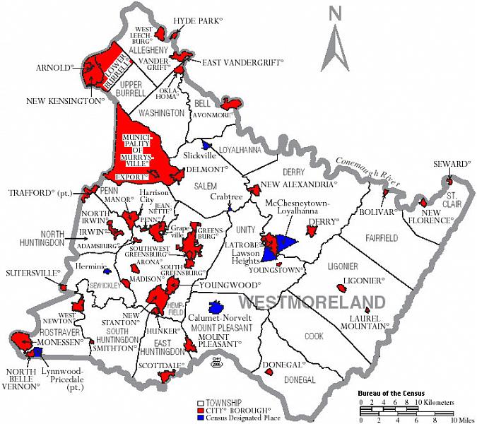
In southwestern PA, east of Pittsburgh, Westmoreland County was organized Feb 26, 1773 (prior to statehood) from Bedford County. It was named for the former county of Westmorland in northwest England, with a slight spelling change.
Area (sq mi): 1,036.34 (Land: 1,025.48 Water: 10.86).
Pop 2005: 367,635.
Pop per sq mi: 358.5.
State Rank: 10.
www.answers.com/topic/westmoreland-county-pennsylvania#...
www.co.westmoreland.pa.us/
www.starofthewest.org/
www.inwestmoreland.com/
Area (sq mi): 1,036.34 (Land: 1,025.48 Water: 10.86).
Pop 2005: 367,635.
Pop per sq mi: 358.5.
State Rank: 10.
www.answers.com/topic/westmoreland-county-pennsylvania#...
www.co.westmoreland.pa.us/
www.starofthewest.org/
www.inwestmoreland.com/
Wikipedia article: http://en.wikipedia.org/wiki/Westmoreland_County,_Pennsylvania
Nearby cities:
Coordinates: 40°21'35"N 79°26'22"W
- Somerset County, Pennsylvania 8.5 km
- Randolph County, West Virginia 156 km
- Rockingham County, Virginia 169 km
- Pocahontas County, West Virginia 197 km
- Augusta County, Virginia 209 km
- Greenbrier County, West Virginia 264 km
- Kanawha County, West Virginia 287 km
- Bedford County, Virginia 307 km
- Robeson County, North Carolina 602 km
- Fulton County, Georgia 838 km
- Unity Township 7.5 km
- Salem Township 8.3 km
- Derry Township 11 km
- Mount Pleasant Township 21 km
- Ligonier Township 24 km
- Cook Township 25 km
- Fairfield Township 26 km
- Donegal Township 28 km
- West Wheatfield Township 29 km
- Jenner Township 38 km