Geographic Center of the 48 States
USA /
Kansas /
Lebanon /
World
/ USA
/ Kansas
/ Lebanon
World / United States / Kansas
region, geography
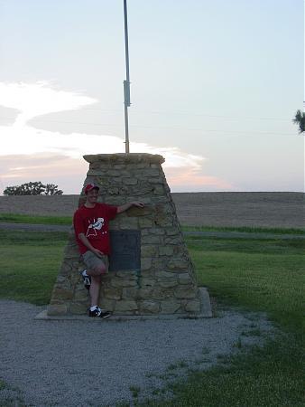
The geographic Center of the US is 1 mile west of US Hwy 281 at the end of Kansas Hwy 191, northwest of Lebanon, KS.
Location of the geographical center of the United States was established by the government geodetic survey of 1898. Financed by the business and professional people of Lebanon, a stone marker north and west of town was dedicated on June 29, 1941.
When Alaska and Hawaii were added as States, Lebanon's site became the Historical Geographical Center of the 48 States or the Contiguous United States.
Nearby cities:
Coordinates: 39°49'41"N 98°34'46"W
- Central Core 487 km
- Platinum Corridor 769 km
- Telecom Corridor 777 km
- Trinity River Greenbelt Park 789 km
- Stemmons Corridor 792 km
- Oak Cliff 800 km
- Pleasant Grove 807 km
- Corona, Tennessee 883 km
- Reverie, Tennessee 888 km
- North Memphis 907 km
- Bellaire, Kansas 8.7 km
- Cora, Kansas 10 km
- Smith Center High School 17 km
- Fairview Cemetery 18 km
- Smith Center Municipal Airport 20 km
- Waconda Lake 41 km
- Wastewater 45 km
- Osborne Municipal Airport 45 km
- Kirwin Reservoir 55 km
- Kirwin National Wildlife Refuge 56 km