Eisenhower-Johnson Memorial Tunnels
USA /
Colorado /
Montezuma /
Interstate 70
World
/ USA
/ Colorado
/ Montezuma
World / United States / Colorado
tunnel
Add category
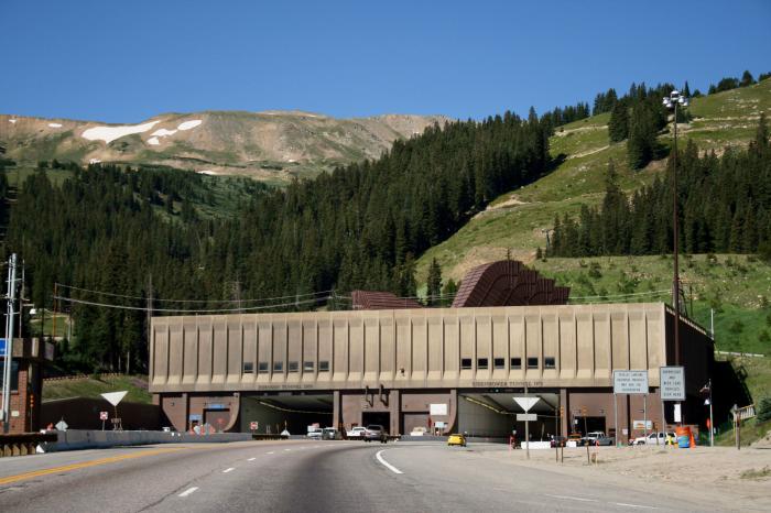
Where I-70 goes through the continental divide.
The westbound bore (<) is named after U.S. President Dwight D. Eisenhower (for whom the Interstate system is also named), the eastbound bore (>) after Edwin C. Johnson, a former governor and U.S. Senator from Colorado.
From Wikipedia, the free encyclopedia
The Eisenhower Tunnel is a vehicular tunnel located at 39.679°, -105.92° on Interstate 70 approximately 60 miles (100 kilometers) west of Denver, Colorado. The tunnel was built under the Continental Divide, and at 11,158 feet (3,401 m), is the highest vehicular tunnel in the world. It is also the longest tunnel built under the Interstate highway program, and one of the last major pieces of the system to be completed. Its full official name is the Eisenhower-Johnson Memorial Tunnel; the westbound bore is named after U.S. President Dwight D. Eisenhower (for whom the Interstate system is also named), the eastbound bore after onetime Colorado governor and U.S. Senator Edwin C. Johnson.
The tunnel is a two-bore tunnel, with each bore approximately 1.7 miles (2.7 km) long. Construction of the westbound bore was started on March 15, 1968 and finished on March 8, 1973. The eastbound bore was started on August 18, 1975 and completed in December 21, 1979. From 1973 to 1979 the westbound bore carried a single lane of traffic in each direction. The total construction cost was $108 million. In 2002, over ten million vehicles passed through the tunnel, many of them driving between the Denver area and popular skiing locations west of the Continental Divide. The eastern end of the tunnel is under and surrounded by the Loveland ski area.
Bicyclists and trucks that cannot safely pass through the tunnel must take the long and steep climb and descent across Loveland Pass. Tourists who want to take a photograph from the scenery at an elevation of 12,000 feet (3,658 m) above mean sea level must also take Loveland Pass. Aside from that, the tunnel has replaced the pass. When the high pass is snowed shut hazardous cargoes have to wait until heir tunnel is cleared of all other vehicles. Then they go through alone. (pricey)
The west portal, at 11,158 feet above sea level, is the highest point on the entire U.S. Interstate system.
Wikipedia article: http://en.wikipedia.org/wiki/Eisenhower_Tunnel
Nearby cities:
Coordinates: 39°40'43"N 105°55'9"W
- Henderson Tunnel West Portal 16 km
- Henderson Mine and Mill conveyor 23 km
- Moffat Tunnel 28 km
- Canal Tunnel 356 km
- Canal Tunnel 1077 km
- Sutro Tunnel 1179 km
- Elizabeth Tunnel 1239 km
- Tehachapi Tunnel 1257 km
- Claremont Water Tunnel (EBMUD) 1428 km
- BART Transbay Tube 1443 km
- Loveland Ski Area 1.7 km
- Seven Sisters avalanche chutes above US 6 2.5 km
- Herman Gulch 5.4 km
- Arapahoe Basin Ski Resort 6.7 km
- Dillon Valley, Colorado 11 km
- Urad Mine 11 km
- Mt Ptarmigan 12 km
- Henderson Mine 12 km
- Henderson Mine mill 23 km
- Henderson Mine Tailings Pond 26 km
Comments