Ibyuk Pingo
Canada /
Northwest Territories /
Tuktoyaktuk /
World
/ Canada
/ Northwest Territories
/ Tuktoyaktuk
World / Canada / Northwest Territories / Inuvik
mountain
Add category
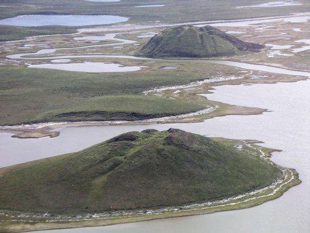
A pingo is an ice mountain.
A pingo, also called a hydrolaccolith, is a mound of earth-covered ice found in the Arctic and subarctic that can reach up to 70 metres (230 ft) in height and up to 600 m (2,000 ft) in diameter. The term originated as the Inuvialuktun word for a small hill. A pingo is a periglacial landform, which is defined as a nonglacial landform or process linked to colder climates.
Periglacial suggests an environment located on the margin of past glaciers. However, freeze and thaw cycles influence landscapes outside areas of past glaciation. Therefore, periglacial environments are anywhere freezing and thawing modify the landscape in a significant manner.They are essentially formed by ground ice which develops during the winter months as temperatures fall.
Wikipedia article: http://en.wikipedia.org/wiki/Pingo
Nearby cities:
Coordinates: 69°23'57"N 133°4'46"W
- Vuntut national Park. 311 km
- Caribou Pass, Arctic National Wildlife Refuge 328 km
- Mount Isto (8,976 ft/2,736 m) 422 km
- Mount Michelson (Brooks Range) 439 km
- Mount Chamberlain 465 km
- Mount Igikpak 918 km
- Pupik Hills Range 996 km
- Mount Pelly 1105 km
- Telavirak Hills 1304 km
- Mount Matheson 1477 km
- Pingo National Landmark 1.5 km
- Hadven Island 45 km
- Lake Itkrilek 47 km
- Parsons Lake 55 km
- Lake Tagle 73 km
- Lower Island 79 km
- Caribou Hills 88 km
- Williams Island 89 km
- Sitidgi Lake 97 km
- Lake Rufus 123 km