Heusden
Netherlands /
Noord-Brabant /
Aalburg /
World
/ Netherlands
/ Noord-Brabant
/ Aalburg
World / Netherlands / Noord-Brabant
fortification, historic city center
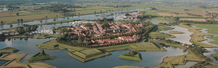
Heusden dates to the 12th century and became a city in the 13th century. On the River Maas, was the site of many battles. The French took from 1672 until 1795 to occupy the city.
Lots more info and picture on:
www.walledtowns.com/wtfc/towninfo/netherlands/heusden.h...
Lots more Webshots Photos: www.webshots.com/search?query=netherlands+heusden&new=1
Lots more info and picture on:
www.walledtowns.com/wtfc/towninfo/netherlands/heusden.h...
Lots more Webshots Photos: www.webshots.com/search?query=netherlands+heusden&new=1
Wikipedia article: http://en.wikipedia.org/wiki/Heusden
Nearby cities:
Coordinates: 51°43'56"N 5°8'20"E
- Fort Crevecoeur 8.6 km
- Fort Giessen 10 km
- Fortified city of Zaltbommel 12 km
- Fort Vuren 13 km
- Castle/Stronghold Loevestein 13 km
- Woudrichem Fortifications 14 km
- Gorinchem Fortifications 16 km
- Fort Altena 16 km
- Fortress "Honswijk". Hollandse waterlinie 27 km
- Batestein Castle moat 30 km
- Heusden (municipality) 5.2 km
- Aalburg 5.4 km
- Zaltbommel (municipality) 5.6 km
- Hedel (old municipality) 8.8 km
- Maasdriel (municipality) 12 km
- 's-Hertogenbosch (municipality) 15 km
- West Betuwe (municipality) 16 km
- North Brabant 23 km
- South Holland 53 km
- Gelderland 69 km
Comments