Fairford Station Industrial Estate
United Kingdom /
England /
Fairford /
A417
World
/ United Kingdom
/ England
/ Fairford
industrial estate, historic site, former train/railway station
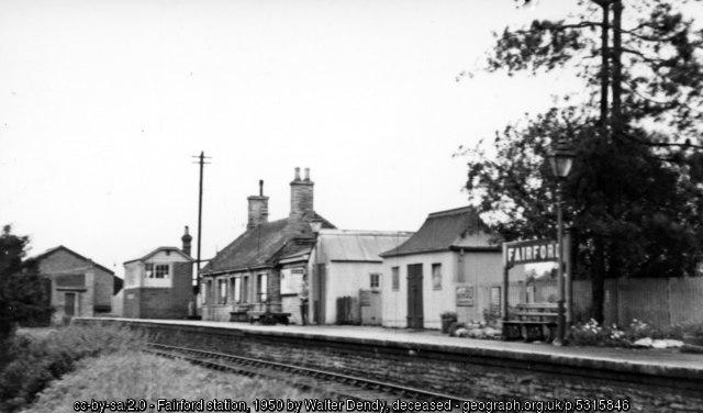


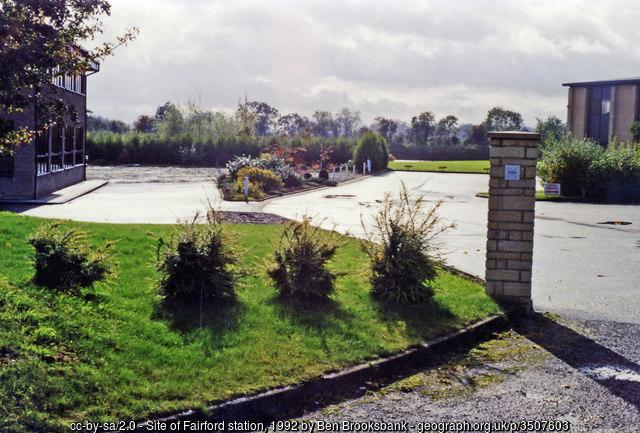
Industrial Estate on the site of the former East Gloucestershire Railway's terminus (closed 1962).
There is a very good write-up with many historic photographs at www.fairfordbranch.co.uk/Fairford.htm
Photos:
1) www.geograph.org.uk/photo/5315846 (1950)
2) www.geograph.org.uk/photo/2035726 (1961)
3) www.geograph.org.uk/photo/2202423 (1969)
4) www.geograph.org.uk/photo/3507603 (1992)
There is a very good write-up with many historic photographs at www.fairfordbranch.co.uk/Fairford.htm
Photos:
1) www.geograph.org.uk/photo/5315846 (1950)
2) www.geograph.org.uk/photo/2035726 (1961)
3) www.geograph.org.uk/photo/2202423 (1969)
4) www.geograph.org.uk/photo/3507603 (1992)
Wikipedia article: https://en.wikipedia.org/wiki/Fairford_railway_station
Nearby cities:
Coordinates: 51°42'24"N 1°45'46"W
- Site of Alvescot Station 11 km
- Site of Awre for Blakeny train station *Closed* 48 km
- Former Kineton Station 53 km
- Former Fenny Compton Station 58 km
- (Site of) Palace Gates Disused Railway Line 114 km
- Housing Development (former Epsom Downs station) 114 km
- Former Hucknall Central Station 152 km
- Liverpool Exchange Railway Station (former site of) 207 km
- former FILEY HOLIDAY CAMP Railway Station 293 km
- Disused Langholm Station 392 km
- RAF Fairford 2.8 km
- Castle Eaton Solar Field 7 km
- Former RAF Down Ampney 7 km
- Down Ampney 7.3 km
- Vines Brake 8.4 km
- North Meadow 10 km
- Broad Blunsdon, Swindon 10 km
- South Cerney Golf Course & Driving Range 11 km
- RAF South Cerney 11 km
- Cotswold Water Park 13 km