Volubilis
Morocco /
Meknes-Tafilalet /
Meknes /
route moulay driss zarhoune
World
/ Morocco
/ Meknes-Tafilalet
/ Meknes
, 19 km from center (مكناس)
World / Morocco / Meknès - Tafilalet / Meknès / Zerhoun
temple, ruins, place with historical importance, archaeological site, Roman Empire, interesting place, UNESCO World Heritage Site
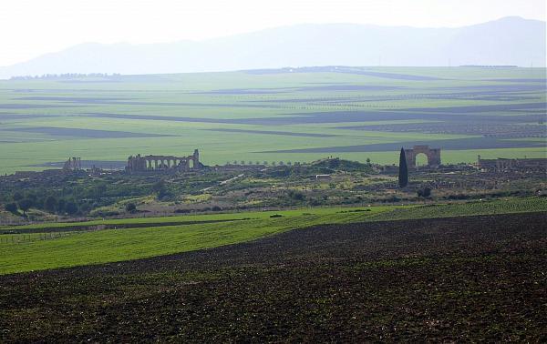
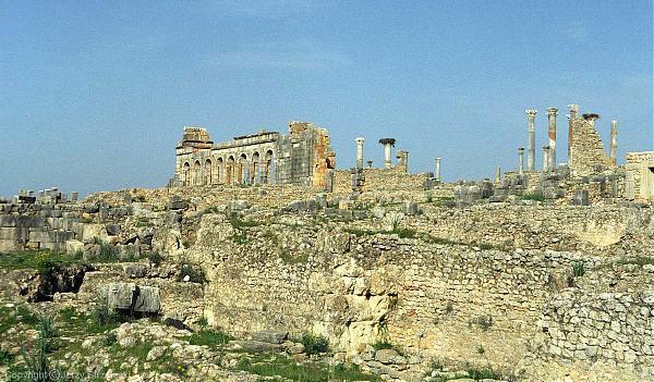
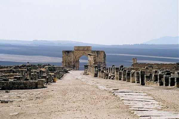
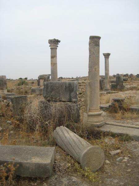
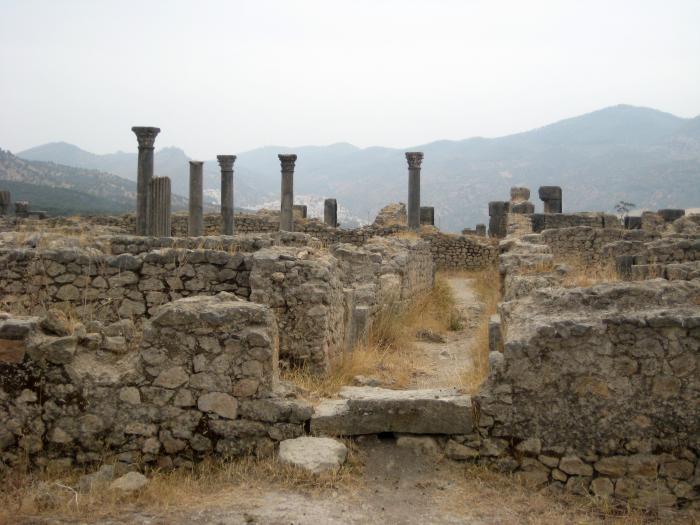
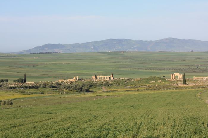
Volubilis is located in modern day Morocco, three kilometers west of Moulay Idriss Zerhoun, in the Jebel Zerhoun Plain. The site’s earliest archaeological remains date to the 2nd c. BCE but there is textual evidence for the site dating to 3rd c. BCE. The site is a Carthaginian settlement. The small settlement had a large sanctuary characteristic of Punic sites. Inside the sanctuary was a central altar with small chapels along the walls. The buildings were primarily made of mud brick. Volubilis was the Mauritanian capital and served as an administrative center for the Roman Empire in Africa (ca. 100 BC – 5th c. AD). The name “Volubilis” is related to the Berber word “oualili” for oleander. The oleander flower is common to the region. Volubilis is also known by the names: Oulili, Walila, and Walili. The most famous remains at the site are the forum, a basilica dating to the 2nd c. CE, and the Arch of Caracalla which dates to ca. 217 CE. Some of the better preserved mosaics which the site is so famous for include Orpheus Mosaics, the Works of Hercules, Diana's Bath, and the Neriedes. The Mauritanian king Juba II is the most associated leader with the site. He was raised in Rome and married Cleopatra Selenus, the daughter of Cleopatra and Mark Antony. He reigned from 25 BC – 23 CE. Under the reign of Juba II Volubilis experienced late Hellenistic culture. The kingdom ended with the death of Ptolemy in 40 CE. In 44 CE Volubilis was annexed to Rome, serving as a municipium, having only partial rights of Roman citizenship. The old kingdom had been divided into two regions, Mauretania Caesariensis in the east, and Mauretania Tingitana in the west. New constructions at the site included temples, baths, and new public buildings. The first aqueduct was built 60-70 CE. Also, there were a lot of oil pressing complexes. Olive oil was probably the main export for Volubilis. The site also exported grains. A city wall was constructed 168-169 CE under the reign of Marcus Aurelius. The gate had eight monumental gates with towers on each side. During the Severan Dynasty the emperor Macrinus built the Capitoline temple in 218 CE and the emperor Caracalla built the Arch of Triumph. In 285 CE Volubilis was abandoned. The site downsized, building a new city wall enclosing a smaller area. There was an earthquake in the late 4th c. CE that affected the site. Christian inscriptions in Latin are found on tombstones at the site from 599 – 655 CE. Idriss I founded the Idrisid dynasty in 788 CE. During his lifetime the site experienced Islamisation. The site was abandoned shortly after this period. In 818 CE people from Andulusia occupied the site. In the 11th c. CE the site overcome by the Almoravid people. Following their period of rule, the site dwindled and was finally destroyed by the Lisbon earthquake in 1755 CE.
Distance from Rome: 1,300 miles
Distance from Athens: 1,648 miles
For More Information:
1.Roman Africa in Color
By Roger Wood and Mortimer Wheeler
2.Morocco: 5,000 Years of Culture
Edited by Vinvent Boele
3.Pictures of the Arch of Triumph
www.euratlas.com/Atlas/maroc/volubilis_caracalla.html
4.Interactive Map of the Site
www.sitedevolubilis.org/MapEN/MapLevel1/MapLevel1.htm
5.Pictures from the site
www.kuhmann.com/poetry/Volubilis.htm
Sources:
1.UNESCO – The Archaeological Site of Volubilis
whc.unesco.org/pg.cfm?cid=31&id_site=836&l=en
2.The Volubilis Project
www.sitedevolubilis.org/www/english/index.htm
3.Britannica – Volubilis
search.eb.com/eb/article-9075712
Wikipedia article: http://en.wikipedia.org/wiki/Volubilis
Nearby cities:
Coordinates: 34°4'24"N 5°33'18"W
- Doñana National Park 358 km
- Banc d'Arguin National Park 1815 km
- Lake District National Park 2305 km
- Mount Nimba Strict Nature Reserve - UNESCO World Heritage Site 2951 km
- Vatnajökull 3528 km
- Great Smoky Mountains National Park 6954 km
- Everglades National Park 7216 km
- Parque Nacional Darién 7912 km
- Sian Ka'an biosphere reserve 8107 km
- Coiba Island 8284 km
- Museum 0.3 km
- Palace of Gordian 0.3 km
- Temple of Saturn 0.3 km
- House of Disciplinae 0.4 km
- بلفقيه 3.9 km
- dadat nemar teourat 4.5 km
- linbiat 6.4 km
- Jbel Zerhoune 6.8 km
- lmrazga 6.8 km
- maison rira 8.5 km
Comments