Banc d'Arguin National Park
Mauritania /
Dahlat Nawadibu /
Nouadhibou /
World
/ Mauritania
/ Dahlat Nawadibu
/ Nouadhibou
, 97 km from center (انواديبو)
nature reserve, invisible, UNESCO World Heritage Site

Ergan Basin Park
fr.: Parc national du Banc d'Arguin (named by the sand banks
near the coastal islands)
"Arkin basin is situated between Ras Nouadhibou and Timeris cap in the north old.wikimapia.org/#lat=20.9142489&lon=-16.7466317&z=11&...
and Dog Bay in the south old.wikimapia.org/#lat=19.3846209&lon=-16.3998757&z=11&... .
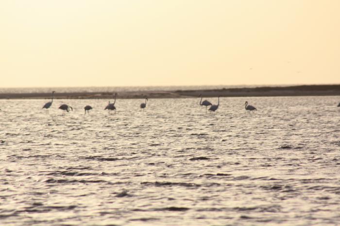
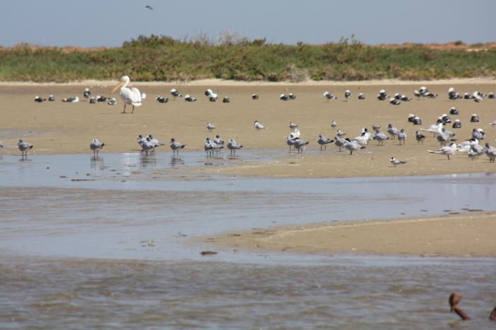
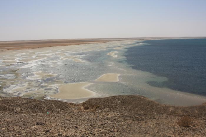
This muddy morass, revered by researchers and scientists, has been declared protected national sanctuary mainly due to the importance of the diversity of bird populations harboring therein. In this basin, one can find flocks of pelicans , the white sparrow, the Royal blond peacock and flamingos which is an excellent bathing station en route to their annual migration, not far from the Shallow basins that show a fascinating scene with different shades of green and blue.
The Mauritanian , which is known as one of the most world's seas rich in fish, represents another abundant cost-effective wealth in economic terms. This wealth is linked to a unique natural phenomenon of cold water rising from the bottom of the ocean, saturated with salt nutrients essential for the growth of plankton that feed on them. Thus, these favorable conditions to the reproduction and growth of fish and crustaceans make the basin an important capital of marine resources whose revenues are reaped by Industrial fishing centered in Nouadhibou, as well as the traditional fishing along the coastline. To the southern of Arkin basin, starting from the town of Onoamgar, there have been living since ancient times communities of Imarkan fishermen groups sandwiched between two oceans - one with salty brackish water while the other contains infinite rocks and sands. Those fishermen have no resources except for the sea fish. The Omarkan fishermen immortalize centuries-old movements , as they go fishing using shoulder-borne nets. When monitors find a swarm of yellow mullet, fishermen rush to the sea to besiege the swarms of fish using their nets amidst a surge of foam torrents tinged with fish blood. From time to time, the fishermen share their catch with the dolphins that emerge to surface after water is strongly beaten with sticks. Women are waiting fish on the beach to conduct their own work, where they tear apart mullet , dry it up; they also treat mullet eggs out of which roe or Mauritanian caviar is made."
qtd.: www.assecaa.org/English/E_tourism_in_mauritania.htm
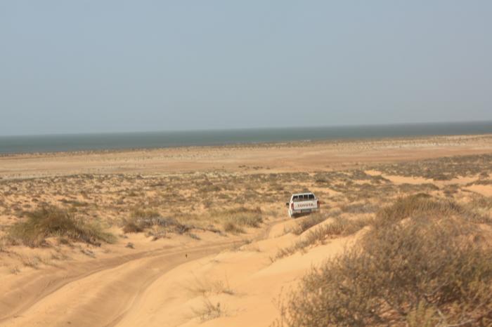
the southern coast area of Ras Nouadhibou is also a part of the park
old.wikimapia.org/#lat=20.6481511&lon=-16.6038952&z=10&...
"There seems to be tight control of the park, and the major threats probably emanate off-shore, where oil exploration is underway, and there is a risk of spillage which would have a devastating impact on the birds. Longer-term, if sea levels rise as a result of global warming, the vast areas of mudflats would be totally submerged and the site would lose its unique qualities. The terrestrial portion of the reserve, though very extensive (6,000 km2), has lost any large mammal fauna it might have had, and its conservation value probably lies mostly as a ‘buffer zone' for the shoreline and marine environment."
qtd.: : www.africannaturalheritage.org/Banc-dArguin-Mauritania/
"Although the park was constituted as a way to protect its environment, overfishing by international fleets in the waters just off Banc d'Arguin, outside the park, is depleting fish resources and may cause a decline of the breeding colonies of fish-eating bird species (Mepham and Mepham, in press). In 2006 Mauritania sold to the EU fishing rights in exchange for external debt reduction, prompting arguments of overfishing, sustainability, Neocolonialism, and the rights of local people."
qtd.: :
fr.: Parc national du Banc d'Arguin (named by the sand banks
near the coastal islands)
"Arkin basin is situated between Ras Nouadhibou and Timeris cap in the north old.wikimapia.org/#lat=20.9142489&lon=-16.7466317&z=11&...
and Dog Bay in the south old.wikimapia.org/#lat=19.3846209&lon=-16.3998757&z=11&... .
This muddy morass, revered by researchers and scientists, has been declared protected national sanctuary mainly due to the importance of the diversity of bird populations harboring therein. In this basin, one can find flocks of pelicans , the white sparrow, the Royal blond peacock and flamingos which is an excellent bathing station en route to their annual migration, not far from the Shallow basins that show a fascinating scene with different shades of green and blue.
The Mauritanian , which is known as one of the most world's seas rich in fish, represents another abundant cost-effective wealth in economic terms. This wealth is linked to a unique natural phenomenon of cold water rising from the bottom of the ocean, saturated with salt nutrients essential for the growth of plankton that feed on them. Thus, these favorable conditions to the reproduction and growth of fish and crustaceans make the basin an important capital of marine resources whose revenues are reaped by Industrial fishing centered in Nouadhibou, as well as the traditional fishing along the coastline. To the southern of Arkin basin, starting from the town of Onoamgar, there have been living since ancient times communities of Imarkan fishermen groups sandwiched between two oceans - one with salty brackish water while the other contains infinite rocks and sands. Those fishermen have no resources except for the sea fish. The Omarkan fishermen immortalize centuries-old movements , as they go fishing using shoulder-borne nets. When monitors find a swarm of yellow mullet, fishermen rush to the sea to besiege the swarms of fish using their nets amidst a surge of foam torrents tinged with fish blood. From time to time, the fishermen share their catch with the dolphins that emerge to surface after water is strongly beaten with sticks. Women are waiting fish on the beach to conduct their own work, where they tear apart mullet , dry it up; they also treat mullet eggs out of which roe or Mauritanian caviar is made."
qtd.: www.assecaa.org/English/E_tourism_in_mauritania.htm
the southern coast area of Ras Nouadhibou is also a part of the park
old.wikimapia.org/#lat=20.6481511&lon=-16.6038952&z=10&...
"There seems to be tight control of the park, and the major threats probably emanate off-shore, where oil exploration is underway, and there is a risk of spillage which would have a devastating impact on the birds. Longer-term, if sea levels rise as a result of global warming, the vast areas of mudflats would be totally submerged and the site would lose its unique qualities. The terrestrial portion of the reserve, though very extensive (6,000 km2), has lost any large mammal fauna it might have had, and its conservation value probably lies mostly as a ‘buffer zone' for the shoreline and marine environment."
qtd.: : www.africannaturalheritage.org/Banc-dArguin-Mauritania/
"Although the park was constituted as a way to protect its environment, overfishing by international fleets in the waters just off Banc d'Arguin, outside the park, is depleting fish resources and may cause a decline of the breeding colonies of fish-eating bird species (Mepham and Mepham, in press). In 2006 Mauritania sold to the EU fishing rights in exchange for external debt reduction, prompting arguments of overfishing, sustainability, Neocolonialism, and the rights of local people."
qtd.: :
Wikipedia article: http://en.wikipedia.org/wiki/Banc_d'Arguin_National_Park
Nearby cities:
Coordinates: 20°17'15"N 16°27'17"W
- Coast of the Seals 205 km
- Park Kheneifis 961 km
- Afrag Anamur n Sus Massa 1304 km
- "Park of the Barbary sheeps" 1719 km
- Mole National Park 1948 km
- Tazekka National Park 1950 km
- Bui National Park 1963 km
- Doñana National Park 2108 km
- Serra da Estrela Natural Park 2411 km
- Regional park of Gredos 2458 km
- Dakhlet Aguadir 40 km
- Tenebrourette lost river 57 km
- Bay of Aouatif 61 km
- Tidra 62 km
- Serenni 69 km
- احديب أغيان 83 km
- Dakhlet Acheil / Baie St.Jean 93 km
- Inkebdene 94 km
- Ndaouas 118 km
- Tazyazte 133 km