Valley Wells
USA /
Nevada /
Sandy Valley /
World
/ USA
/ Nevada
/ Sandy Valley
camp, smelter, historic ruins
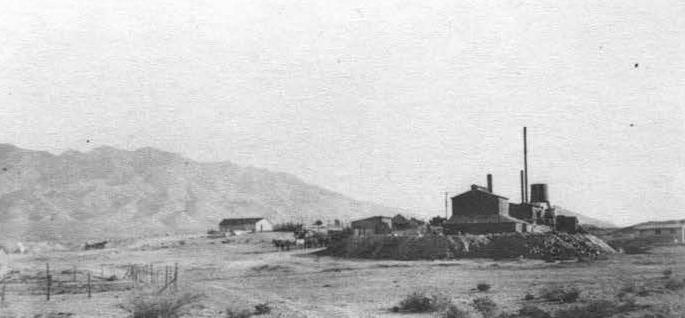
Also known as Rosalie or Rosalie Wells. The wells were drilled in 1898 by the Ivanpah Smelting Company for their copper smelter once located here. It smelted ore from nearby mines such as the Copper World and possibly Mohawk.
20 mule teams hauled copper matte (processed copper ore) first to Manvel (or Barnwell) every four days, and later to the new railhead at Ivanpah II. It was taken by rail via the California Eastern Railway, to the ATSF interchange at Goffs and then to New York for further smelting. After the new blast furnace was installed by the Ivanpah Mining Company in November 1917, copper matte was shipped to Cima and taken to Garfield, UT for further processing. When copper prices fell in 1918 with the end of the First World War, the smelter closed for good.
mrdata.usgs.gov/mrds/show-mrds.php?dep_id=10213792
digital-desert.com/places/rosalie.html
www.vegasunderworld.com/1011201504.html
cali49.com/mojave/2015/10/30/rosalie-cal
www.billyholcomb.com/wp-content/uploads/2016/09/6018S4x...
vredenburgh.org/mining_history/pages/clark_mescal_mtns_...
citeseerx.ist.psu.edu/viewdoc/download?doi=10.1.1.730.9...
Nearby cities:
Coordinates: 35°27'59"N 115°40'53"W
- Mohawk Mine 6.3 km
- Ruin 8 km
- Kelly Field 12 km
- Lv 17 Mine 15 km
- Shenandoah Mill 38 km
- Owl Hole Springs (ruins) 90 km
- Old Ryan, California 114 km
- Tonopah & Tidewater Railroad Wye 114 km
- Mexican Camp 131 km
- Railroad Camp 133 km
- Clark Mountain Range 14 km
- Ivanpah Lake 28 km
- Mesquite Dry Lake 29 km
- Lucy Gray Mountains 39 km
- Kingston Range 39 km
- Sandy Valley, Nevada 40 km
- Mojave National Preserve 43 km
- Charleston View, California 60 km
- Las Vegas, Nevada_duplicate 88 km
- Pahrump, Nevada 89 km