Cizîre/Jazira Region (DFNS)
Syria /
al-Hhasakah /
World
/ Syria
/ al-Hhasakah
/ al-Hhasakah
, 21 km from center (الحسكة)
region, first-level administrative division, draw only border, do not draw title
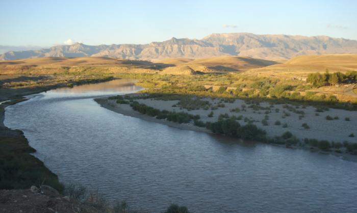


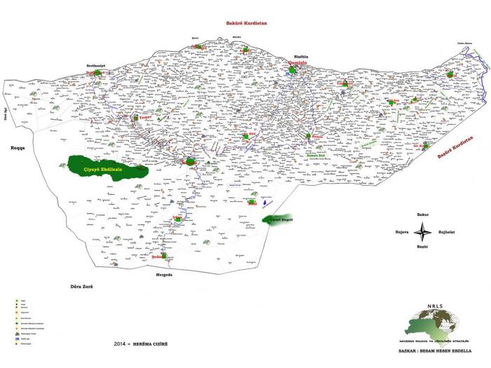
Jazira Region, formerly Jazira Canton, (Kurdish: Herêma Cizîrê, Arabic: إقليم الجزيرة, Classical Syriac: ܦܢܝܬܐ ܕܓܙܪܬܐ, translit. Ponyotho d'Gozarto), is the largest of the three regions of the de facto autonomous Democratic Federation of Northern Syria (DFNS). It consist of two cantons; Qamişlo/Qamishli and Hesîçe/Hasakah. The cantons are subdivided in 2 and 4 areas, respectively. It has the same size and shape as the former Hasakah Governorate.
As part of the liberation campaign for Rojava, its democratic autonomy was officially declared on November 2013, and the Constitution adopted January 21, 2014. Under the Constitution, the city of Qamishli is the administrative center of the Cizire canton. However, as part of Qamishli remains under the control of the Syrian government, the autonomous administration’s meetings take place in the nearby city Amuda.
The only active political party, and founder of the autonomous region, in Rojava is PYD, or Democratic Union Party (kurdish: Partiya Yekîtiya Demokrat). The curent chairman is Saleh Muslim with Asiyah Abdullah as co-chairwoman. PYD was secretly created by remnants of PKK in 2003, when the Syrian Government declared North Kurdistan’s PKK a terrorist organization, and agreed to cooperate with Turkey against it.
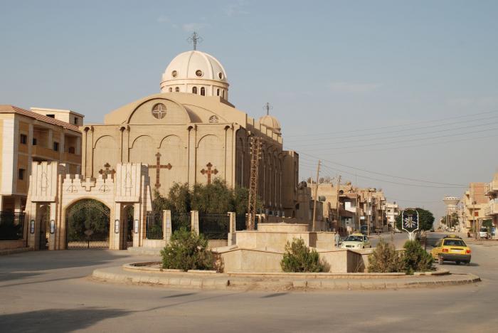
Other major cities in the canton are Hesîçe (Al-Hasakah), Serêkaniyê (Ras al-Ayn), Derika Hemko (Al-Malikiyah), Dirbêsiyê (Al-Darbasiyah) and Tirbespiyê (al-Qahtaniya). The population consists of Kurds, Assyrians (Syriacs), Arabs and Armenians. While the Kurdish, Arabic and Syriac are considered official languages, all communities have the right to teach and learn in their native language. The practiced religions are Islam, Christianity and Yazidism. Between 20-30% of the Canton are Christians of various churches and denominations. All five ethnic communities are represented in the Legislative Assembly of 101 seats. The current prime ministers(sometimes referred to as president) of Jazira Canton are the Kurd Akram Hesso and the arab Hamidi Sheikh Daham (Shammar tribe leader) with the Assyrian Elizabeth Gawrie and Arabic Hussein Al Arab Taza Azam as vice prime ministers (sometimes referred to as vice presidents). The government must Always be composed by a man and a woman. Also, the minorities have fixed number os seats on the Assembly.
Security is maintained by the "Asayish" (a kind of military police) and Sutoro (a kind of Assyrian military police),wich is affiliated to the Syriac Union Party. The Syrian Government forces control the neighborhoods of Tayy, Al Zinud, Halku, the border crossing, the Government building, the Airport, na Army Brigade Base, and some villages on the countryside in Qamishli. In Hasakah, the Regime controls most of the city center, part of Gweran and Naswa districts, the town of Al-Dhiyabah to the north, and the Kawkab Artillary base to the east.
The army of Rojava is the YPG, People’s Protection Units (kurdish: Yekîneyên Parastina Gel), created by PYD in 2004’s Qamishli riots against the Government, and expanded in 2011, with Syria’s Civil War. The army is composed by all-female (YPJ, or Women's Protection Units, kurdish: Yekîneyên Parastina Jin) and mixed brigades. Affiliated to the YPG are the MFS, or Syriac Military Council (composed of Assyrian Christians only brigades) and Al Sanadid (consisting of Arab Shammar tribe, which inhabits the southeastern part of the canton (the towns of Yarubiyah, Tall Brak, Tall Hamis are the biggest).
The Euphrates Volcano (Burkan Al Furat) joint operation room and aliance was stablished in 12/09/2014, and is composed of YPG and many FSA brigades (Liwa Thuwwar al-Raqqa, Jarabulus Brigade , Al-Qassas Army, Jihad in the Path of God Brigade, Jaysh al-Thuwar, Jabhat al-Akrad, Dawn of Freedom Brigades, Northern Sun Battalion and Al-Tahrir Brigade).
As part of the liberation campaign for Rojava, its democratic autonomy was officially declared on November 2013, and the Constitution adopted January 21, 2014. Under the Constitution, the city of Qamishli is the administrative center of the Cizire canton. However, as part of Qamishli remains under the control of the Syrian government, the autonomous administration’s meetings take place in the nearby city Amuda.
The only active political party, and founder of the autonomous region, in Rojava is PYD, or Democratic Union Party (kurdish: Partiya Yekîtiya Demokrat). The curent chairman is Saleh Muslim with Asiyah Abdullah as co-chairwoman. PYD was secretly created by remnants of PKK in 2003, when the Syrian Government declared North Kurdistan’s PKK a terrorist organization, and agreed to cooperate with Turkey against it.
Other major cities in the canton are Hesîçe (Al-Hasakah), Serêkaniyê (Ras al-Ayn), Derika Hemko (Al-Malikiyah), Dirbêsiyê (Al-Darbasiyah) and Tirbespiyê (al-Qahtaniya). The population consists of Kurds, Assyrians (Syriacs), Arabs and Armenians. While the Kurdish, Arabic and Syriac are considered official languages, all communities have the right to teach and learn in their native language. The practiced religions are Islam, Christianity and Yazidism. Between 20-30% of the Canton are Christians of various churches and denominations. All five ethnic communities are represented in the Legislative Assembly of 101 seats. The current prime ministers(sometimes referred to as president) of Jazira Canton are the Kurd Akram Hesso and the arab Hamidi Sheikh Daham (Shammar tribe leader) with the Assyrian Elizabeth Gawrie and Arabic Hussein Al Arab Taza Azam as vice prime ministers (sometimes referred to as vice presidents). The government must Always be composed by a man and a woman. Also, the minorities have fixed number os seats on the Assembly.
Security is maintained by the "Asayish" (a kind of military police) and Sutoro (a kind of Assyrian military police),wich is affiliated to the Syriac Union Party. The Syrian Government forces control the neighborhoods of Tayy, Al Zinud, Halku, the border crossing, the Government building, the Airport, na Army Brigade Base, and some villages on the countryside in Qamishli. In Hasakah, the Regime controls most of the city center, part of Gweran and Naswa districts, the town of Al-Dhiyabah to the north, and the Kawkab Artillary base to the east.
The army of Rojava is the YPG, People’s Protection Units (kurdish: Yekîneyên Parastina Gel), created by PYD in 2004’s Qamishli riots against the Government, and expanded in 2011, with Syria’s Civil War. The army is composed by all-female (YPJ, or Women's Protection Units, kurdish: Yekîneyên Parastina Jin) and mixed brigades. Affiliated to the YPG are the MFS, or Syriac Military Council (composed of Assyrian Christians only brigades) and Al Sanadid (consisting of Arab Shammar tribe, which inhabits the southeastern part of the canton (the towns of Yarubiyah, Tall Brak, Tall Hamis are the biggest).
The Euphrates Volcano (Burkan Al Furat) joint operation room and aliance was stablished in 12/09/2014, and is composed of YPG and many FSA brigades (Liwa Thuwwar al-Raqqa, Jarabulus Brigade , Al-Qassas Army, Jihad in the Path of God Brigade, Jaysh al-Thuwar, Jabhat al-Akrad, Dawn of Freedom Brigades, Northern Sun Battalion and Al-Tahrir Brigade).
Wikipedia article: https://en.wikipedia.org/wiki/Jazira_Region
Nearby cities:
Coordinates: 36°25'28"N 40°56'9"E
- Ezidixan/West-Şingal (EPC) 51 km
- Ezidixan/East-Şingal (mixed EPC-ICR) 72 km
- Erbil governed part of Badush region 156 km
- Sh'eitat Tribal Region 175 km
- ISIS Desert Pocket 246 km
- Qandil (KRG) 326 km
- Sanaee industrial zone. 430 km
- Buhriz 452 km
- Al Rahaliyah 464 km
- الغدير 507 km
- Tishreen Oil Field 1.2 km
- Army fueling station 1.3 km
- Tell Tunainir (Thannuris) 6.2 km
- Tishreen (al-Hawl) Oil field 8.6 km
- Container & supply depot 9 km
- Defensive trench 11 km
- Maqlea Site 13 km
- Tell Taban 16 km
- Hasakah South Dam Reservoir 17 km
- Hasakah district 35 km
Comments