North Sinjar Subdistrict, Şengalê Bakur
Iraq /
Ninawa /
Sinjar /
World
/ Iraq
/ Ninawa
/ Sinjar
, 15 km from center (سنجار)
draw only border, subdistrict, do not draw title
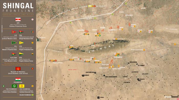
Şengalê Bakur, Kuzey Şengal (KRG). It was a district of the Nineveh Governorate, Iraq. The district seat was the town of Sinjar. The district has four subdistricts, al-Shemal, al-Qayrawan, al-Qahtaniyah and Şhengal. The district is one of two major population centers of the Yazidi with the other being Shekhan District. The majority of the population is Kurdish. The Sinjar mountains are the most sacred place to the Yezidi, witch have Kurdish origin.
History:
The district was created in 1934 by Royal decree. After the 1935 Yazidi revolt, the district was place under military control.
The district borders and is a crossing point with Syria. The district is 136 km from Mosul city, the capital of the Nineveh Governorate. The Sinjar Mountains are located in the district. The district's economy is primarily based on agriculture with the main crops being barley, figs, wheat, and tobacco. In the villages of Ain al-Ghazal and Hayali exist oil fields, which were closed because of the Iraq war. Natural gas and heavy minerals exist in the Sinjar Mountains.
Generally speaking the area covered by Yazidi migrations, extended as far north as the Wadi al-Radd and reached the al -Bidi settlement 25 kilometers south of Wardiyyah, and Yazidi flock s seldom grazed further west than the Khatuniyyah lake. Various factors related to political and ecological conditions, played a determining role in securing Yazidi nomads access to t h e i r pastures outside the Jabal Jaribah.
Among the most important were the extent of or lack of state control over the people of the plains , Yazidi relations with the Arab Bedouin leadership and favourable climatic conditions which could guarantee sufficient animal fodder.
UNAMI was provided documentation of a government campaign that destroyed 137 Yazidi villages in the Jebel Sinjar mountains following the collapse of the 1975 Kurdish movement. Tens of thousands of village inhabitants were forcibly settled into eleven collective compounds primarily located in Shemal.
Wikipedia article: https://en.wikipedia.org/wiki/Sinjar_District
Nearby cities:
Coordinates: 36°27'11"N 41°56'41"E
- Nineveh Governorate (ICR) 86 km
- Saladin Governorate (ICR) 98 km
- Kirkuk Governorate 143 km
- Hewlêr/ Erbil Governorate 158 km
- Deir ez-Zor Civil Council (DFNS) 201 km
- Cizîre/Jazira Region (DFNS) 238 km
- Al-Qa'im District (ICR) 241 km
- Deir ez-Zor Governorate (PCS) 254 km
- Markaz Rutba Subdistrict (ICR) 389 km
- Al-Walid Subdistrict (ICR) 401 km
- Yusefan (Ausfa) prior to 1975 4.6 km
- كاليئ مزارئ بيرئ اورا galye mezare pere aura 5.1 km
- Shrine of Sherfedin 7.3 km
- Çêl Mêra eastern ridge 8.3 km
- Bir Sohor area 8.3 km
- Balistan area 9 km
- Taraf (prior to 1975) 10 km
- Sini Çêl Mêra (1463 m) 11 km
- Solagh agricultural area 16 km
- Sinjar Mountains (1463 m) 29 km
Comments