Devil's backbone
USA /
Kentucky /
Goshen /
World
/ USA
/ Kentucky
/ Goshen
World / United States / Indiana
interesting place, draw only border, stone/rock feature
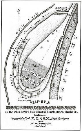
Devil's Backbone is a rock formation and peninsula formed by the flow of Fourteen Mile Creek into the Ohio River, and is currently situated in Charlestown State Park near Charlestown, Indiana. According to local legend, on this bedrock ridge once stood a stone fortress that was built by Welsh explorers led by Prince Madoc sometime in the 12th century.
The Backbone is believed to have been formed by the processes of glaciation where a combination of ice sheet advances, meltwater flows and a diversion of the Ohio River left an isolated bedrock ridge remaining between two valleys.
The Backbone is believed to have been formed by the processes of glaciation where a combination of ice sheet advances, meltwater flows and a diversion of the Ohio River left an isolated bedrock ridge remaining between two valleys.
Wikipedia article: http://en.wikipedia.org/wiki/Devil's_Backbone_(rock_formation)
Nearby cities:
Coordinates: 38°25'50"N 85°36'57"W
- Old Jeffersonville Historic District 20 km
- former Highland Park neighborhood 29 km
- Wild Bill Cantrell Hydroplane Racecourse 39 km
- Fort Duffield 57 km
- Perryville Battlefield State Historic Site 101 km
- Overbrook Farm 112 km
- Holiday World & Splashin' Safari 119 km
- future I-66/Northwestern Bypass interchange 168 km
- Wolf Creek Dam 178 km
- Old Mulkey Meetinghouse State Park 195 km
- Charlestown State Park 1.3 km
- Tunnel Mill Boy Scout Reservation 6 km
- Heritage Place 7.5 km
- Clark County, Indiana 7.8 km
- Hidden River Valley 8.2 km
- Greyrock Quarry 10 km
- Speed 12 km
- Oldham County, Kentucky 14 km
- Champions Pointe Golf Club 18 km
- Floyd County, Indiana 28 km