Hoosier Hill (Highest point in Indiana)
USA /
Ohio /
Hollansburg /
World
/ USA
/ Ohio
/ Hollansburg
hill, highpoint
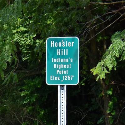
Nestled in the woods of a remote section of Wayne County, Indiana lies Hoosier Hill, the state's high point at 1,257 feet above sea level. The point is on private property, but in 2005 with the owner's blessing, Eagle Scout candidate Kyle Cummings of Lakeside Park, Kentucky built a sign, a dedicated trail, and a picnic area at the highpoint to facilitate visits.
Wikipedia article: http://en.wikipedia.org/wiki/Hoosier_Hill
Nearby cities:
Coordinates: 40°0'4"N 84°50'55"W
- Hide Away Hills 207 km
- Bon Harbor Hills 317 km
- Friendship Hill National Historic Site 420 km
- Pine Hill Trails 440 km
- Turkey Hill 715 km
- Sand Mountain 761 km
- 7 Sisters (Hill area on Long Island) 1004 km
- High Hill 1032 km
- Jessamine Lake Northeast Hill 1309 km
- Highest point in Polk county 1389 km
- Whitewater, Indiana 6.3 km
- Spartanburg, Indiana 7.3 km
- Northeastern High School 9 km
- Williamsburg, Indiana 14 km
- Headwaters Wind Farm 17 km
- Randolph County Airport 20 km
- Fountain Park Cemetery 21 km
- Wayne County, Indiana 21 km
- Randolph County, Indiana 22 km
- Preble County, Ohio 33 km