Fort Sumter
USA /
South Carolina /
Sullivans Island /
World
/ USA
/ South Carolina
/ Sullivans Island
World / United States / South Carolina
monument, military, fortification, NRHP - National Register of Historic Places, historic district


South Carolina 29412
www.nps.gov/fosu/
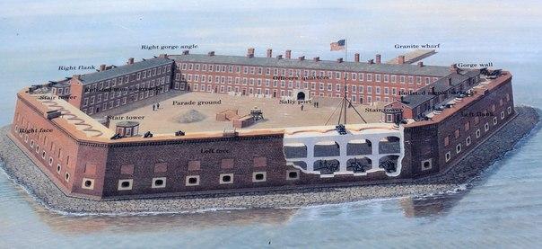
This Third-System masonry coastal fortification begun in 1829, was named after General Thomas Sumter.
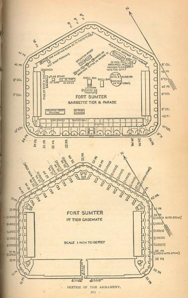
As of 1851, it was intended to be armed with forty-one 42-pounder seacoast guns, forty-one 32-pounder seacoast guns, thirty-three 24-pounder guns, nine 12-pounder guns, four field pieces, twelve 8" heavy seacoast howizters, two 10" heavy mortars, two 10" light mortars and two 8" light mortars, for a total of 146 guns.
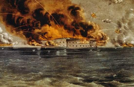
The fort is best known as the site of the first battle of the American Civil War, the Battle of Fort Sumter in April 1861. After the secession of South Carolina, Union troops had withdrawn from Fort Moultrie to Fort Sumter, and the unwillingness of President Lincoln to recall them and allow the Confederacy to take possession of the fort eventually lead to its bombardment by on-shore batteries. The fort surrendered after two days of bombardment and was occupied by Confederate forces. From 1863 to February 1865 the fort was blockaded and periodically bombarded by Union gunboats taking part in the blockade of Charleston Harbor. When Confederate forces withdrew from Charleston in February 1865, the fort was reoccupied by Union forces.
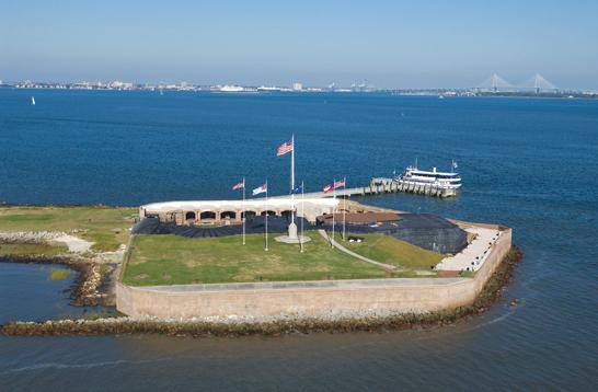
After the Civil War, the fort's strategic location had not diminished. the Army cleaned up the wartime debris, and later filled in most of the original fort with a massive conrete gun position that was named Battery Huger. It was equipped with two 12-inch guns, one disappearing and one barbette mounted. It served as a military fort until 1948, when it was designated a National Monument.
www.youtube.com/watch?v=YrKrXPMidvU
www.nps.gov/fosu/
This Third-System masonry coastal fortification begun in 1829, was named after General Thomas Sumter.
As of 1851, it was intended to be armed with forty-one 42-pounder seacoast guns, forty-one 32-pounder seacoast guns, thirty-three 24-pounder guns, nine 12-pounder guns, four field pieces, twelve 8" heavy seacoast howizters, two 10" heavy mortars, two 10" light mortars and two 8" light mortars, for a total of 146 guns.
The fort is best known as the site of the first battle of the American Civil War, the Battle of Fort Sumter in April 1861. After the secession of South Carolina, Union troops had withdrawn from Fort Moultrie to Fort Sumter, and the unwillingness of President Lincoln to recall them and allow the Confederacy to take possession of the fort eventually lead to its bombardment by on-shore batteries. The fort surrendered after two days of bombardment and was occupied by Confederate forces. From 1863 to February 1865 the fort was blockaded and periodically bombarded by Union gunboats taking part in the blockade of Charleston Harbor. When Confederate forces withdrew from Charleston in February 1865, the fort was reoccupied by Union forces.
After the Civil War, the fort's strategic location had not diminished. the Army cleaned up the wartime debris, and later filled in most of the original fort with a massive conrete gun position that was named Battery Huger. It was equipped with two 12-inch guns, one disappearing and one barbette mounted. It served as a military fort until 1948, when it was designated a National Monument.
www.youtube.com/watch?v=YrKrXPMidvU
Wikipedia article: http://en.wikipedia.org/wiki/Fort_Sumter
Nearby cities:
Coordinates: 32°45'8"N 79°52'28"W
- Naval Weapons Station Charleston 32 km
- MCAS Beaufort 86 km
- Parris Island Marine Corps Recruit Depot 92 km
- Hunter Army Airfield 148 km
- Fort Jackson 181 km
- Fort Stewart 202 km
- Fort Gordon 246 km
- Camp Mackall 258 km
- Fort Bragg 284 km
- Robins Air Force Base (WRB/KWRB) 350 km
- Spider Island 1.4 km
- Cummings Point 1.7 km
- Boat Launch 1.8 km
- Fort Moultrie National Monument 1.9 km
- USS Patapsco (wreck) 2.3 km
- Officers Quarters 2.7 km
- Charleston Harbor 3.1 km
- Sullivan's Island Fire&Rescue 3.4 km
- Morris Island 4.4 km
- USS Weehawken (wreck) 5.3 km
Comments