Damurhuda Upazila HQ
Bangladesh /
Chuadanga /
Damurhuda /
World
/ Bangladesh
/ Chuadanga
/ Damurhuda
World / Bangladesh / Khulna / Kushtia / Choua Danga
township, subdistrict, fourth-level administrative division, local government
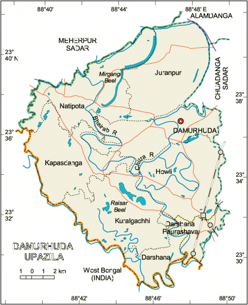
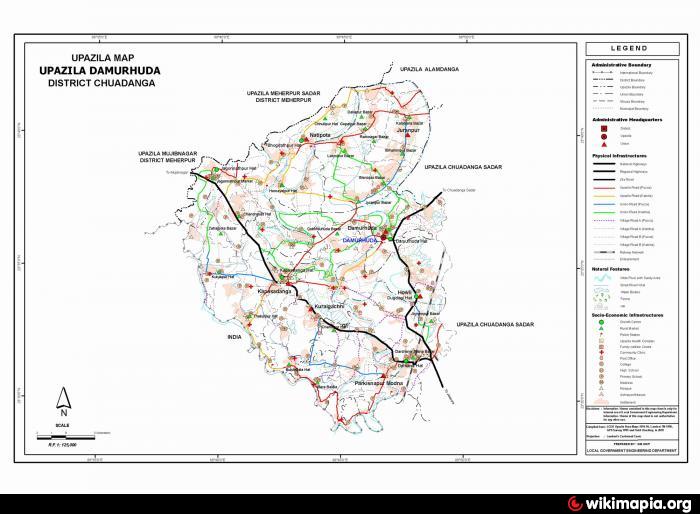
Damurhuda Upazila (Chuadanga district) with an area of 308.11 sq km, is bounded by Meherpur sadar and Alamdanga upazilas on the north, West Bengal of India on the south, Chaudanga sadar upazila on the east, Meherpur Sadar upazila and West Bengal on the west. Main rivers are Chitra, Bhairab.
The location of the Damurhuda town is 23.6014426N 88.7740303E. Damurhuda (Town) consists of three mouzas. It has an area of 10.52 sq km. The town has a population of 9185; male 51.58%, female 48.42%; population density per sq km 873. Literacy rate among the town people is 26.9%.
Damurhuda thana was turned into an upazila in 1983. It consists of one municipality, three wards, 7 union parishads, 93 mouzas and 102 villages.
As of the 1991 Bangladesh census: Population 213291; male 51.69%, female 48.31%; Muslim 97.32%; Hindu 1.99%, Christian 0.66% and others 0.03%.
Religious institutions: Mosque 160, temple 4, church 3 noted of which is Shibnagar Mosque.
Literacy and educational institutions: Average literacy 25.8%; male 29.6% and female 21.4%. Educational institutions: college 2, high school 15, primary school 108, madrasa 10, kinder garden school 2. Noted educational institution: Natudaha High School (1906).
Cultural organisations: Rural club 12, public library 1, Islamic library 1, cinema hall 3, theatre and cultural organisation 9, women's organisation 1, press club 1.
Main occupations: Agriculture 41.38%, agricultural labourer 28.23%, wage labourer 2.5%, commerce 12.13%, service 8.19% and others 7.47%.
Land use: Total cultivable land 22145.87 hectares; single crop12.32%, double crop 70.20% and treble crop land 17.48%.
Land control: Among the peasants 17.85% are landless, 17.40% marginal, 25.42% small, 31.27% intermediate and 8.06% rich.
Fisheries, dairies, poultries Poultry 25, fishery 1, dairy 9.
Communication facilities- Roads: pucca 56.5 km, semi pucca 35.5 km and mud road 327.9 km.
Manufactories: Sugar mill, rice mill, flour mill, ice factory, saw mill, welding.
Cottage industries: Weaving, bamboo works, goldsmith, blacksmith, potteries, construction work, bidi and tailoring.
NGO activities: Operationally important NGOs are brac, asa, WAVE, Usha.
Health centres: Upazila health complex 1, family planning centre 7.
Nearby cities:
Coordinates: 23°35'48"N 88°46'45"E
- Abhaynagar Upazila HQ 84 km
- Fakirhat Upazila HQ 128 km
- Koyra Upzila HQ 144 km
- Kachua Upazila HQ 150 km
- Bholahat Upazila HQ 163 km
- Sarishabari Upazila 168 km
- Gobindaganj Upazila 187 km
- Shaghatta Upazila 197 km
- Maidi Vdc 629 km
- Samote Union Council 1852 km
- Chuadanga District 3.4 km
- Raisha Beel 6.1 km
- Karpasdanga 8.1 km
- Kutubpur 13 km
- Nuton Durbes pur 13 km
- Baradi BADC Farm 15 km
- Mujibnagar Upazila 19 km
- Meherpur District 22 km
- Meherpur Sadar Upazila HQ District Town 24 km
- Khulna Division 96 km