Matiranga Upazila HQ
Bangladesh /
Khagrachhari /
Khagrachari /
World
/ Bangladesh
/ Khagrachhari
/ Khagrachari
World / Bangladesh / Chittagong / Khagrachari / Khagrachari
township, subdistrict, fourth-level administrative division, local government
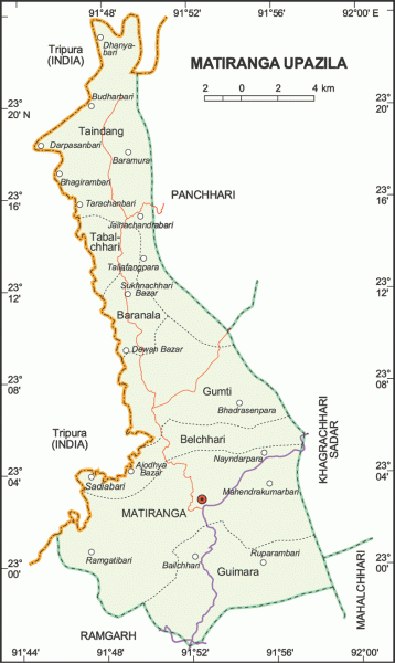
Matiranga Upazila (Khagrachhari district) with an area of 388.68 sq km, is bounded by the Indian State of Tripura on the north and west, Ramgarh upazila on the south, Panchhari, Khagrachhari sadar and Mahalchhari upazilas on the east Main rivers are Feni and Pilac; notable tilas are Alu Tila, Birashi Tila, Bhagaban Tila and Lakshmichhari Tila.
Matiranga is located at 23.0417°N 91.8750°E. Matiranga (Town) consists of one mouza. It has an area of 2.59 sq km. The town has a population of 6426; male 57.89% and female 42.11%; population density per sq km 2481. Literacy rate among the town people is 45.8%. The town has two dakbungalows.
Matiranga thana, now an upazila, was established in 1980. The upazila consists of seven union parishads, 28 mouzas and 256 villages.
Religious institutions: Mosque 55, temple 27, pagoda 25 and sacred place 1 (Matai Pukhiri).
As of the 1991 Bangladesh census: Population 71949; male 52.38%, female 47.62%; Muslim 72.09%, Hindu 20.38%, Buddhist 7.46% and others 0.07%.
Literacy and educational institutions: Average literacy 24.1%; male 33.4% and female 13.6%. Educational institutions: college 1, high school 10, madrasa 7, government primary school 70, non-government primary school 22. Noted educational institution: Tabalchhari Kadamtoli High School (1959).
Cultural organisations: Public library 1, rural club 10, cinema hall 5, women's organisation 4, playground 20.
Main occupations: Agriculture 39.24%, fishing 1.13%, commerce 8.95%, agricultural labourer 24.67%, wage labourer 8.32%, services 6.05% and others 11.64%.
Land use: Total cultivable land 7569.81 hectares, fallow land 1389.31 hectares; single crop 21%, double crop 45% and treble crop land 34%.
Main crops: Paddy, arum, sugarcane, potato, brinjal, sweet pumpkin, corn, marka, cucumber, turmeric, ginger, arhar (kind of pulses) and tomato.
Fisheries, dairies, poultries Fishery 60, poultry 36 and hatchery 1.
Communication facilities- Roads: pucca 81 km, semi pucca 50 km and mud road 270 km.
Manufactories- Saw mill 35, plywood factory 2, brickfield 12, flour mill 2.
Cottage industries: Weaving 16, bamboo & cane work 2, welding 4, blacksmith 58, wood work 2, tailoring 95.
NGO activities: Operationally important NGOs are brac, German-Bangla Friendship Society and Bandarban Buddhist Orphanage.
Health centres: Upazila health complex 1, family planning centre 8, rural health centre 1 and sub health centre 3.
Nearby cities:
Coordinates: 23°2'8"N 91°52'5"E
- Patiya Upazila (পটিয়া) 76 km
- Chandanaish Upazila 84 km
- Banshkhali Upazila (বাঁশখালী উপজেলা) 95 km
- Matlab Upazila (North) Area 143 km
- Rupganj Upazila 170 km
- Lohajang Upazila 177 km
- Keraniganj Upazila 184 km
- Kapashia Upazila 197 km
- Gafargaon Upazila 221 km
- Dhobaura Upazila 286 km
- Jaliapara 10 km
- Alutila Hill 11 km
- Khagrachari District Town 13 km
- khabongparia Residential Area, 93/B 13 km
- BGB Sector HQ, Khagrachhari 15 km
- Khagrachari District 20 km
- Fatikchhari Upazila (ফটিকছড়ি উপজেলা) 30 km
- Rangamati District 54 km
- Chattogram District Area 66 km
- Tripura 80 km