Daulatpur Upazila HQ
Bangladesh /
Kushtiya /
Bheramara /
World
/ Bangladesh
/ Kushtiya
/ Bheramara
World / Bangladesh / Khulna / Kushtia / Kustia
township, subdistrict, fourth-level administrative division, local government
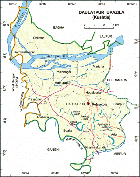
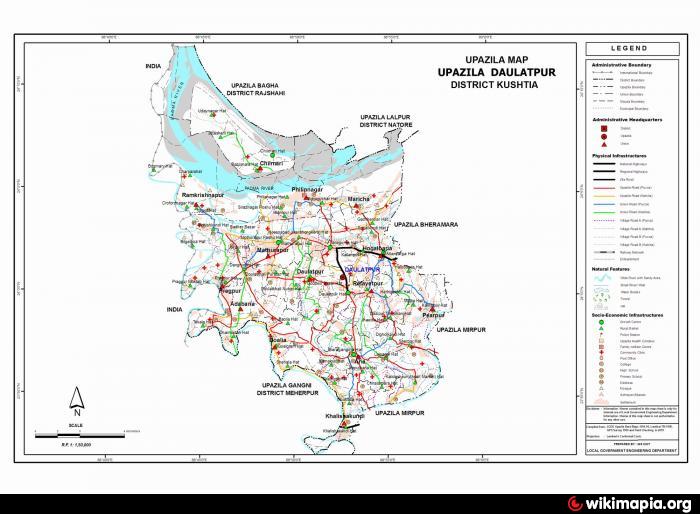
Daulatpur Upazila (Kushtia district) with an area of 468.76 sq km, is bounded by Bagha and Lalpur upazilas on the north, Gangni and Mirpur (Kushtia) upazilas on the south, Bheramara and Mirpur upazilas on the east, West Bengal of India on the west. Main rivers are Ganges and Mathabhanga.
The location of Daulatpur town is 24.0026741N 88.8750724E. Daulatpur (Town) consists of two mouzas with an area of 15.41 sq km. The population of the town is 13989; male 51.59%, female 48.41%. The density of population is 908 per sq km. Literacy rate among the town people is 26.8%. The town has a dakbungalow.
Daulatpur thana was turned into an upazila in 1983. It consists 14 union parishads, 153 mouzas and 242 villages.
Archeological heritage and relics Nilkuthir at Sonaikundi, Hosenabad and Mahishkundi.
As of the 1991 Bangladesh census, Population 360706; male 51.42%, female 48.58%; Muslim 99.28%, others 0.72%.
Religious institutions Mosques 160, temple 1 and church 1.
Literacy and educational institutions Average literacy 20.5%; male 25% and female 15.7%. Educational institutions: college 11, high school 45, government primary school 105, non-government primary school 82, madrasa 35, vocational training institute 1, orphanage 1. Noted educational institutions: Pragpur Government Primary School (1905) and Bagwan Khirodchandra Bidya Niketan and Mathurapur High School (1948).
Cultural organisations Public library 1, Shilpakala Academy 1, theatregroup 4, cinema hall 3, rural club 156, women's organisation 4, literary and cultural group 2 and playground 85.
Main occupations Agriculture 33.6%, agricultural labourer 30.41%, wage labourer 15.22%, industry 1.06%, service 3.17%, others 10.73%.
Land use Cultivable land 27,198.99 hectare; fallow land 799.68 hectare; single crop 36.92%, double crop 41% and treble crop 22.08%. Land under irrigation 14399 hectare.
Land control Among the peasants 20.29% are landless, 50.5% small, 26.21% medium, 3% large.
Fisheries, dairies, poultry farms Fishery 7, poultry 250, hatchery 2.
Communication facilities Roads: pucca 68 km, semi pucca 119 km, mud road 702 km; waterways 8 nautical mile.
Manufactories Cigarette factory 2, match factory 1, polythene industry 1.
Cottage industries Weaving 665, bamboo work 12, goldsmith 71, tailoring 439 and welding 42.
NGO activities Operationally important NGOs are brac, asa, EMPD, Palashipara Samajkalyan Samiti, Shahebnagar Samajkalyan Sanstha, BASA, AHDO and JASA.
Health centres Upazila health complex 1, satellite clinic 2, family planning centre 14, maternity and child care hospital 1, clinic 1.
Nearby cities:
Coordinates: 24°0'3"N 88°51'59"E
- Abhaynagar Upazila HQ 116 km
- Bholahat Upazila HQ 127 km
- Sarishabari Upazila 128 km
- Gobindaganj Upazila 142 km
- Shaghatta Upazila 152 km
- Fakirhat Upazila HQ 157 km
- Kachua Upazila HQ 179 km
- Koyra Upzila HQ 184 km
- Maidi Vdc 600 km
- Samote Union Council 1830 km
- Rayta pathor ghat (bahadurpur) 13 km
- Char Bhabnanda Diar 15 km
- Udainagar 20 km
- BAJIT PUR,NADIA 22 km
- Jalangi, Murshidabad 23 km
- Meherpur District 28 km
- Oxbow Lake 33 km
- Paikmari Domkal Murshidabad 742304 36 km
- Khulna Division 131 km
- Rajshahi Division 136 km