Bhurngamari
Bangladesh /
Kurigram /
Nageshwari /
World
/ Bangladesh
/ Kurigram
/ Nageshwari
World / Bangladesh / Rajshahi / Ranpur / Kurigram
township, subdistrict, fourth-level administrative division, local government
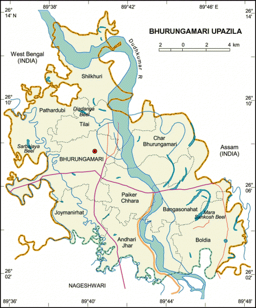
Bhurungamari Upazila (Kurigram district) with an area of 236 sq km, is bounded by west Bengal and Assam (Indian states) on the north, Nageshwari upazila on the south, Assam on the east, West Bengal on the west. Dudhkumar is the main river.
Bhurungamari is located at 26.1250°N 89.6833°E. It has 33984 units of house hold. Bhurungamari (Town) consists of three mouzas. It has an area of 14.92 sq km. The town has a population of 19885; male 51.66%, female 48.34%; density of population is 1333 per sq km. Literacy rate among the town people is 33.1%.
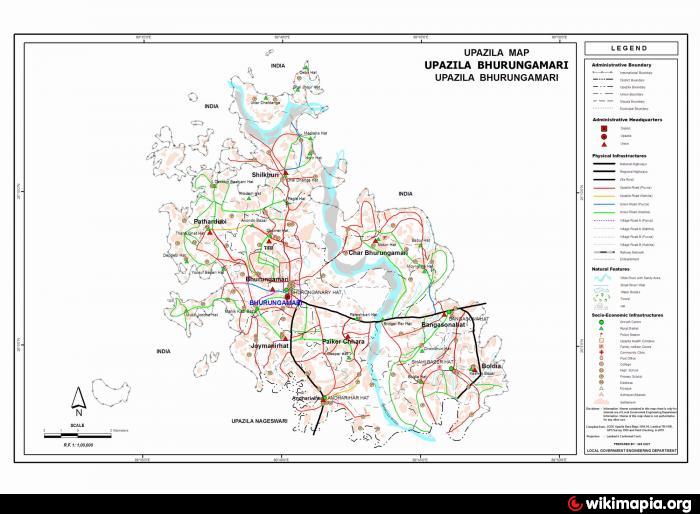
Bhurungamari upazila consists of 10 union parishads, 70 mouzas, 10 enclaves and 124 villages.
Heritage and relics: Zamindar Bari (house) at Joymoni, remnants of an ancient mosque on the south-west of Pateshwari Bazar (Mughal period) and the Sonaihata Bridge on the boarder of India and Bangladesh.
As of the 1991 Bangladesh census, Population 176822: male 50.38%, female 49.62%; Muslim 98.16%, Hindu 1.74% and others 0.10%.
Religious institutions Mosque 510, temple 12.
Average literacy 19.5%; male 26.2% and female 12.6%. Educational institutions: college 3, high school 24, madrasa 15, government primary school 62, non-government primary school 62. Noted educational institutions: Bhurungamari Pilot High School (1925), Pateshwari Barkatia High School (1950).
Main occupations Agriculture 49.36%, fishing 1.01%, agricultural labourer 29.62%, wage labourer 2.51%, commerce 5.66%, transport 1.49%, service 2.44% and others 7.91%.
Land use Total cultivable land 17035.39 hectares; single crop 14.20%, double crop 50.64% and treble crop 35.16%; land under irrigation 33.24%.
Land control Among the peasants 30% are landless, 40% small, 20% intermediate and 10% rich; cultivable land per head 0.10 hectare.
Fisheries, dairies and poultries Dairy 37, fishery 1, nursery (fish) 20, poultry 32.
Cottage industries Weaving 3, bamboo work 40, goldsmith 25, blacksmith 48, potteries 195, wood work 165, tailoring 20, cocoon production 15, cobbler 10 and welding 4.
Communication facilities Roads: pucca 27 km, semi pucca 10 km and mud road 800 km; waterways 42 nautical mile.
Health centres: Upazila health complex 1, family planning centre 3, private clinic 1, dispensary 4.
NGO activities Operationally important NGOs are brac, CARE, rdrs, asa, Chhinnamukul.
Bhurungamari is located at 26.1250°N 89.6833°E. It has 33984 units of house hold. Bhurungamari (Town) consists of three mouzas. It has an area of 14.92 sq km. The town has a population of 19885; male 51.66%, female 48.34%; density of population is 1333 per sq km. Literacy rate among the town people is 33.1%.
Bhurungamari upazila consists of 10 union parishads, 70 mouzas, 10 enclaves and 124 villages.
Heritage and relics: Zamindar Bari (house) at Joymoni, remnants of an ancient mosque on the south-west of Pateshwari Bazar (Mughal period) and the Sonaihata Bridge on the boarder of India and Bangladesh.
As of the 1991 Bangladesh census, Population 176822: male 50.38%, female 49.62%; Muslim 98.16%, Hindu 1.74% and others 0.10%.
Religious institutions Mosque 510, temple 12.
Average literacy 19.5%; male 26.2% and female 12.6%. Educational institutions: college 3, high school 24, madrasa 15, government primary school 62, non-government primary school 62. Noted educational institutions: Bhurungamari Pilot High School (1925), Pateshwari Barkatia High School (1950).
Main occupations Agriculture 49.36%, fishing 1.01%, agricultural labourer 29.62%, wage labourer 2.51%, commerce 5.66%, transport 1.49%, service 2.44% and others 7.91%.
Land use Total cultivable land 17035.39 hectares; single crop 14.20%, double crop 50.64% and treble crop 35.16%; land under irrigation 33.24%.
Land control Among the peasants 30% are landless, 40% small, 20% intermediate and 10% rich; cultivable land per head 0.10 hectare.
Fisheries, dairies and poultries Dairy 37, fishery 1, nursery (fish) 20, poultry 32.
Cottage industries Weaving 3, bamboo work 40, goldsmith 25, blacksmith 48, potteries 195, wood work 165, tailoring 20, cocoon production 15, cobbler 10 and welding 4.
Communication facilities Roads: pucca 27 km, semi pucca 10 km and mud road 800 km; waterways 42 nautical mile.
Health centres: Upazila health complex 1, family planning centre 3, private clinic 1, dispensary 4.
NGO activities Operationally important NGOs are brac, CARE, rdrs, asa, Chhinnamukul.
Nearby cities:
Coordinates: 26°6'32"N 89°39'57"E
- Shaghatta Upazila 98 km
- Gobindaganj Upazila 108 km
- Sarishabari Upazila 142 km
- Bholahat Upazila HQ 196 km
- Abhaynagar Upazila HQ 340 km
- Fakirhat Upazila HQ 368 km
- Kachua Upazila HQ 383 km
- Koyra Upzila HQ 417 km
- Maidi Vdc 528 km
- Samote Union Council 1762 km
- Torsa River 15 km
- River Sankosh ( Dudhkumar ) merges with the mighty Brahmaputra River 23 km
- chagal chara 29 km
- Dolphin Lake 33 km
- South Dhubri 34 km
- India-Bangladesh Border 34 km
- Dhubri District 34 km
- Kurigram District 39 km
- Rajshahi Division 122 km
- Meghalaya 179 km